Knowledge / Navigation and marine safety
AIS latency: timestamps, extrapolation and comparing moving targets
Reconstruct AIS data age, align observations to one time and quantify the limits of straight-line extrapolation during acceleration or turning.
On this page
Two target symbols can disagree because they refer to different moments. Time alignment can explain part of the offset, but only if timestamps and prediction rules are understood. A corrected position is still a modelled estimate when the target has not been observed again.
A position needs an observation time
An AIS position report describes a position associated with a particular measurement process. By the time it appears on another vessel’s display, sensing, message assembly, radio transmission, reception, processing and display update may all have occurred. The age of the displayed position is therefore a different quantity from the nominal interval between radio reports.
For a data comparison, distinguish measurement time, transmit time if available, reception time and display time. A shore service may add network transport, aggregation and caching, so its arrival timestamp is not necessarily the shipboard radio reception time. A fast-refreshing web map can redraw an old report many times. Animation smoothness is not evidence of fresh observations.
Read the timestamp field according to its message type
The USCG Class A position-report description for messages 1, 2 and 3 identifies a six-bit timestamp carrying the UTC second associated with the electronic positioning report. Values 0–59 represent seconds; 60 means unavailable, 61 manual input, 62 estimated/dead-reckoning mode and 63 an inoperative positioning system. Those special values are status codes, not extra seconds to add to a clock.
A second-of-minute field is not a complete date-time. Reconstructing age needs reception context, a credible clock and rules for minute rollover. A report marked second 58 and received at second 03 may be five seconds old across a minute boundary, or older if the delivery path was delayed. The field alone cannot distinguish all possibilities. Other AIS message types and station classes require their own definitions.
Align positions to one explicit comparison time
In a local east/north plane, constant-velocity propagation is p(t*) = p(t0) + vG(t0)(t* − t0). The velocity must be over ground if the position coordinates are ground-referenced. Use seconds with metres per second, or hours with knots and nautical miles. Heading cannot replace COG in this translation model unless a separate justified relation is established.
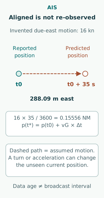
For an original example, a target moving steadily at 16 kn has a position 35 s old. Its assumed displacement is 16×35/3,600 = 0.15556 NM, or 288.09 m. If the track is due east, the entire correction is eastward; on another track it must be decomposed into components. The calculation illustrates age-related offset, not a prescribed AIS reporting interval or an acceptable error.
Extrapolation introduces a motion-model assumption
Propagating an old position can improve time alignment while making the display less directly observational. The propagated point is where the model expects the target to be, not a new measured position. If the target accelerates or turns, the residual grows with the unobserved interval. Displaying the point without its age and prediction status hides that distinction.
For a separate original constant-acceleration example, suppose an unmodelled acceleration of 0.020 m/s² acts along one axis for 45 s. Constant-velocity extrapolation misses 0.5×0.020×45² = 20.25 m in that axis. This is conditional on the stipulated acceleration; it is not an AIS accuracy specification. Unknown manoeuvres require an uncertainty description rather than pretending that an extrapolated coordinate is exact.
A turn creates cross-track prediction error
Assume a fictional target reference point initially moves north over ground at 8.0 m/s and then follows a circular ground track turning steadily to starboard at 6°/min for 45 s, at constant ground speed. The course-over-ground change is 4.5°. With angular rate ω = π/1,800 rad/s, circular-motion displacement is east = (v/ω)(1 − cos ωt) = 14.13 m and north = (v/ω)sin ωt = 359.63 m.
A straight extrapolation would place it 360.00 m north and zero east. The discrepancy is therefore dominated by the 14.13 m lateral component in this invented short turn. The acceleration example in the previous section is a different scenario and should not be added to this result. A turn-rate field can support another model only when its validity, age and meaning are established.
Reference points must remain consistent after alignment
Even perfectly synchronized positions can refer to different physical points. An AIS position is tied to the transmitting vessel’s positioning reference and configured dimensions; a radar track can follow an effective reflecting point that changes with aspect. On a large hull, the difference can be substantial without either coordinate being a simple random error.
If a comparison moves an AIS antenna position to another hull point, it needs the correct offset and contemporaneous heading. During rotation, that point has additional motion relative to the antenna. A late heading combined with a fresh position can therefore leave a geometry error after time alignment. Do not remove an apparent discrepancy by arbitrarily shifting a symbol until it overlaps the radar echo.
Missing reports are not evidence of unchanged motion
If no new report arrives, the last known position remains the last known position. Reception can be affected by radio conditions, antenna geometry, channel loading or an intervening service. A target may also change its motion during that gap. The receiving system’s lost-target logic and any extrapolation should be understood from its documented behaviour.
MCA MGN 324 Amendment 2 warns against relying on AIS as a replacement for lookout and systematic radar information. Its operational caution is consistent with the timing analysis: a fresh-looking symbol may still contain wrong, incomplete or stale source data. AIS information supports the overall navigation picture; it does not establish that an unreported object is absent.
A useful comparison preserves provenance
For each plotted point, retain message type, source time or status code, reception time, comparison time, source identifier, reference point and any propagation model. Record whether a service supplied raw reports or already extrapolated positions. Extrapolating an already predicted position a second time can double-count elapsed motion.
In an original audit example, two datasets have identical receipt times but one contains raw antenna positions and the other contains provider-predicted hull-centre positions. A simple coordinate subtraction mixes both time processing and geometry. The correct comparison first resolves those definitions; only then can a residual be interpreted as possible sensor disagreement.
Report uncertainty rather than a polished track alone
Common errors include confusing broadcast interval with latency, reading special timestamp codes as seconds, losing a minute rollover, propagating with heading instead of COG and treating a smooth line as measured motion. Another is inferring navigational intent from a stale velocity vector.
The useful output states the age interval that can actually be supported, the assumptions behind propagation and the residual after compatible time and point references are established. Where age cannot be reconstructed reliably, say so. An exact-looking corrected coordinate should never conceal an unknown clock or an unobserved manoeuvre.
Sources
- Class A AIS Position Report, messages 1–3 · US Coast Guard NAVCEN · Source check date: 2026-10-06
- MGN 324 (M+F) Amendment 2 · UK MCA · Source check date: 2026-10-06