Knowledge / Navigation and marine safety
Chart survey quality and CATZOC: accuracy, coverage and interpretation
Interpret CATZOC as combined evidence about position, depth and seabed search, with worked tolerances and clear statistical limits.
On this page
Chart quality is most useful when it changes the questions asked about the seabed. A category can explain how data were assessed, but cannot supply a missing survey or predict every future change. Separating accuracy, coverage and currency avoids several misleading shortcuts.
Quality is not one number
CATZOC combines information about horizontal position, depth accuracy and seabed coverage. IHO S-66, edition 2.0.0, section 7.1 distinguishes assessed categories A1, A2, B, C and D from U, which means unassessed. A chart can be fully updated while the source survey remains old or incomplete. The category describes evidence underlying the chart; it is neither an assurance of current seabed condition nor a direct probability of grounding.
Consider three questions separately: How close is a depicted feature to its true position? How close is its depicted depth to the measured reality? How thoroughly was the area searched for features between measurements? A precise answer to one cannot supply the missing answers to the others. This is why a clean display with many decimal places can coexist with significant uncertainty about an obstruction.
Depth tolerance and survey-order tolerance differ
IHO S-68, edition 1.0.0, tables 6-1–6-4 shows that CATZOC and survey-order requirements do not use interchangeable formulae. For CATZOC, the listed depth tolerance is linear in depth: A1 uses 0.5 m + 0.01d; A2 and B use 1.0 m + 0.02d. The S-44 survey-order expression instead has the form sqrt(a² + (bd)²). Substituting one expression for the other changes its meaning and result.
In an original example at charted depth d = 18.0 m, the A1 expression gives 0.68 m and the A2/B expression gives 1.36 m. At d = 42.0 m they give 0.92 m and 1.84 m. These computations reproduce category expressions for teaching. They do not establish the actual error at a particular sounding, and they do not convert a category into an approved under-keel allowance.
The same depth tolerance can hide different coverage
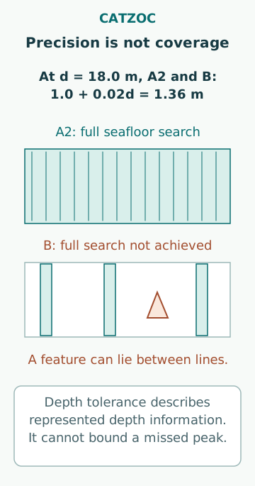
A2 and B share the depth expression above, yet they do not represent the same seabed search. This is a decisive distinction. Imagine two fictional rectangles with identical depth precision at every measured point. In one, the required area search and significant-feature detection were achieved; in the other, widely separated survey lines leave portions between them insufficiently examined. A narrow pinnacle can fall in those spaces.
Adding 1.36 m to a margin in the second rectangle does not quantify the height of a feature that was never detected. The depth-error model applies to represented depth information; completeness is a separate issue. A simple “chart depth minus category allowance” spreadsheet can therefore look conservative while leaving the dominant uncertainty outside its model. The appropriate response depends on official information and the full passage assessment.
Horizontal uncertainty can dominate near a slope
An obstruction’s position error and own-ship positioning error are different quantities. Better GNSS does not move a charted rock into its correct location. In a narrow channel, uncertainty perpendicular to the channel can be more consequential than the same uncertainty along its length. A circular position category alone does not describe the vessel’s remaining manoeuvring space.
For an illustrative local seabed slope of one metre vertically per twenty metres horizontally, a 30 m horizontal displacement corresponds to a 1.50 m depth difference in that idealized direction. The arithmetic is 30/20. It is not an extra CATZOC correction: the actual slope may be nonlinear or discontinuous, and some survey uncertainties are already correlated. The example demonstrates a mechanism by which a nominally horizontal question becomes a vertical one.
Confidence is not a collision-frequency statement
Where the category definition uses a stated confidence level, that statistical statement concerns the data-quality quantity and its specified assumptions. It does not mean there is a corresponding probability that a ship will ground on a passage. Grounding also depends on the route, hull geometry, actual seabed, water level, vessel motions, observation errors and operational decisions.
Nor does a confidence interval necessarily provide a hard bound that the true value can never exceed. A calculation must preserve whether an input is a standard uncertainty, a confidence interval, a tolerance or an engineering allowance. Mixing them and then reporting a precise percentage produces a number with no defensible statistical interpretation. The same caution applies to multiplying several nominal confidence levels as though all errors were independent.
A recent chart can describe an older seabed
Update date, survey date and seabed stability are separate attributes. A chart update may alter a buoy or administrative information without replacing the bathymetric survey. An excellent survey in a mobile sand-wave area can become less representative as the bed changes. A less recent survey over stable rock raises a different question. Age alone is therefore an incomplete ranking tool.
A fictional harbour record might contain a current ENC, a dredged-area note with an older stated date and a recent local notice reporting shoaling. The analytical task is to reconcile those specific statements, their authority and spatial extent. Do not silently replace official chart data with an informal depth claim, and do not ignore a relevant current warning because the electronic update indicator is green. The unresolved discrepancy itself belongs in the assessment.
Inspect metadata without promoting it beyond its meaning
Quality information may be area-wide or attached to a particular feature. An object report can help identify which depth, position and survey attributes are actually encoded. Missing metadata is an absence of information, not evidence of zero error. Likewise, a modern survey method named in a record does not prove that every quality criterion was achieved in the delivered chart.
The allocation process described by S-68 evaluates several criteria rather than assigning a category from the sensor name alone. For a reading exercise, take one chart feature and trace its position, depth, area category, any feature-specific qualifications and relevant survey dates. Record which conclusions each item supports. The result is a compact evidence chain; it should retain uncertainty instead of collapsing everything into a single reassuring letter.
Turn quality into explicit decision assumptions
A useful assessment identifies where uncertainty changes materially along the route, which vessel and environmental margins already address which effects, and what additional authoritative information is available. It must also distinguish quantified errors from unknown completeness. If the dominant concern is an uncharted feature, more decimal places in a depth subtraction do not resolve it.
Common mistakes include reading U as the best category or as zero uncertainty, equating A2 with B because their depth formula matches, using the S-44 square-root expression for CATZOC, assuming a 95% data statement is a 5% accident probability and treating chart currency as new survey coverage. The goal is a traceable understanding of the evidence, not a universal clearance number or permission to navigate a particular area.
Sources
- S-66 Facts about Electronic Charts and Carriage Requirements · IHO · Source check date: 2026-10-06
- S-68 Guidelines and Recommendations for Allocation of CATZOC/QOBD · IHO · Source check date: 2026-10-06