Athens’ Double Standard at Sea
Greece gave some of its islands reduced effect in delimiting its boundary with Italy. The line it agreed with Egypt stopped short of Meis. Why, then, should the median line be a vested right opposite Türkiye?
In this article
Summary
Does owning an island determine how much sea it can claim against the opposite coast? The treaties Greece signed with Italy and Egypt offer an answer. Some small Greek islands received reduced weight against Italy, and the Egyptian agreement settled only part of the boundary. Türkiye likewise defends its maritime rights along the entire A–B segment it agreed with Libya on the basis that the two states’ coasts face one another. The distinction matters from Meis, just off Kaş, to the waters south of Crete. An island’s entitlement and the effect of that island on a boundary are two successive questions. Greek claims about Aegean airspace, Kardak, the military status of the islands and gas off Cyprus also have to answer to the documents on which Athens relies. Sometimes the most searching objection lies in the very next clause of a treaty Greece signed. [1, 2, 3, 4, 5, 6]
Athens at two negotiating tables
On 26 August 2020, Prime Minister Kyriakos Mitsotakis stood before the Greek parliament in Athens to defend a maritime agreement with Italy. He explained that some small Greek islands had counted for less in drawing the line. Elsewhere the boundary had shifted in Greece’s favour. To the prime minister, this was a bargain he could defend. His government had taken account of the coast opposite and secured a gain for Greece in return. [1]
Consider what Greece had put to Türkiye. In its 1976 application to the International Court of Justice in The Hague, Athens argued that only the median line could divide the eastern Aegean islands from Anatolia. It even recorded its earlier answer to the Turkish delegation. Greece considered that it already held the rights up to that line and had no obligation to negotiate any part of them away. A year later, the very first article of its treaty with Italy allowed minor, mutually agreed adjustments to the median line. What changed in a year? The principle had not changed. Greece now faced a different coastal state, and Athens had changed the language it used at the negotiating table. [7, 8, 9]
Why does this matter to Türkiye? A continental shelf extends seaward from Kaş, Antalya and the Aegean shores of Anatolia. A coastal state acquires the right to explore and exploit the natural resources of that seabed by virtue of its coast. Its neighbour’s approval is unnecessary. A separate question arises where two coastal entitlements overlap. There the states must determine where their boundary lies. That was precisely what Rome and Athens negotiated. If Greece treats its own share as already secured before it sits down with Ankara, it also presumes to decide what Türkiye is allowed to negotiate. [10, 11, 12, 7]
Mavi Vatan, or Blue Homeland, is one name for Türkiye’s answer. Cem Gürdeniz introduced the term in 2006. The 462,000 square kilometres cited in the Turkish parliament include parts of the Black Sea already delimited with neighbouring states, alongside stretches of the Aegean and Mediterranean still awaiting agreement. Three questions give that figure legal meaning. What rights arise from a particular stretch of Anatolian coast? Where does the neighbouring state’s coast begin? How should a boundary between them be drawn? The Anatolian coast itself gives Türkiye rights over the seabed. Where entitlements overlap, a boundary has to take both coasts into account. Greece has shown how this can be done in its agreements with its western and southern neighbours. The first was Italy. [13, 14, 12]
Where did the Greek–Italian median line shift?
Article 1 of the treaty Greece and Italy signed in Athens on 24 May 1977 took the median line as its starting point and allowed small adjustments acceptable to both countries. A median line joins points equally distant from the two coasts. An island just offshore can substantially change the answer depending on whether the measurement starts from the island or the mainland behind it. Greece and Italy made that choice point by point along a line defined by sixteen points. When they signed a new agreement on maritime zones, again in Athens, on 9 June 2020, they used the same line. The bargain Mitsotakis defended in parliament can be seen on the chart. [8, 15, 1]
The 1982 study by the US Department of State lets the reader check that bargain point by point. Point 2 lies 23.5 nautical miles from the Italian coast and 20.2 from the Greek island of Othoni. A nautical mile is 1,852 metres. Strict equidistance would have produced two identical distances. At point 6 it did, giving 78 nautical miles to each coast. At point 8 the line shifts closer to Italy. The measurements the Department took from its own chart bear out the prime minister’s account. Greece accepted a smaller seaward reach for an island in one sector and gained ground in another. [16, 8]
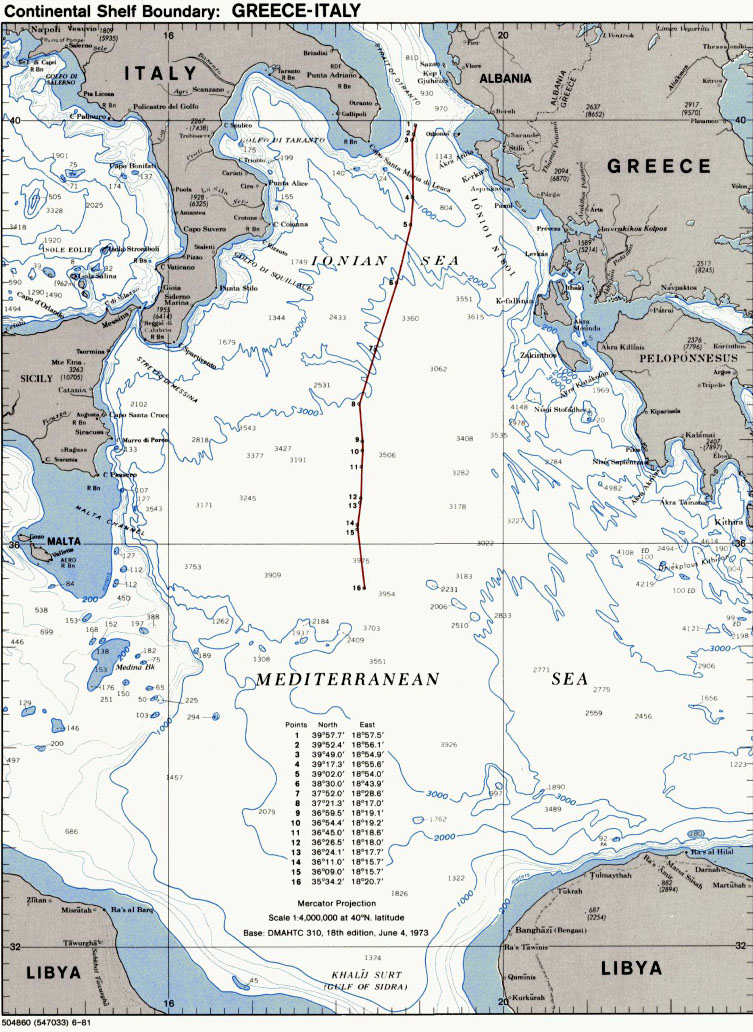

What can Türkiye draw from this agreement? The treaty gives Türkiye no entitlement to the same distances as Italy. The more important concession is one of principle. Greece can retain full sovereignty over an island while agreeing to give it less weight against another country’s coast. Türkiye may therefore insist that its own coast be weighed in delimitation in the Aegean and the Mediterranean. Athens is free to explain the geographical differences between Othoni and Meis. Having allowed that question to be negotiated with Italy, Athens cannot rule it out altogether in talks with Türkiye. The next signature to consider is Egypt’s. [10, 1, 8]
Where does Cairo’s signature end?
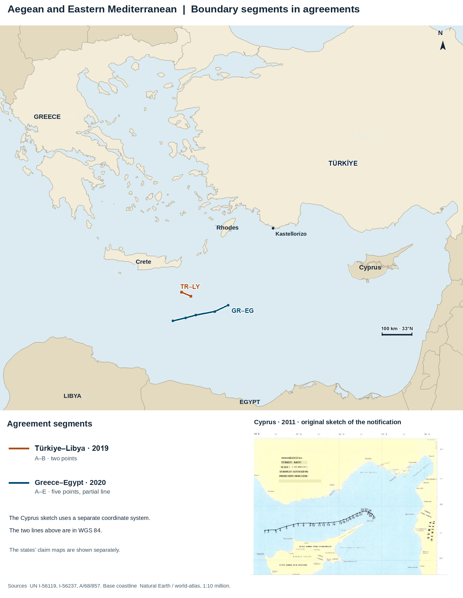
The treaty with Egypt shows most clearly where the signed boundary ends, even as Athens invokes the median line as a principle against Ankara. The first article of the Greek–Egyptian text of 6 August 2020 calls the delimitation partial. The two states agreed on only five points. The easternmost, point A, lies at 33°53′05″N, 27°59′02″E. The agreed line therefore ends just short of the 28th meridian east. Meis lies farther east. No document supports the claim that Türkiye has accepted a boundary in that sector to which even Egypt did not put its signature. [1, 2]
Mitsotakis mentioned Meis in the same speech, arguing that the agreement with Egypt showed that islands could generate maritime entitlements. He immediately added that negotiations would continue over the sectors still open. Few documents illustrate so neatly the gap between an island having an entitlement and that entitlement reaching a particular point off Kaş. There is no need to guess why Egypt stopped precisely there. A text that provides for future negotiations leaves their outcome open. [1, 2, 18]
The diplomatic record is explicit. In November 2019, Greece’s foreign ministry treated Ankara’s insistence that other coastal states had to be considered west of the 28th meridian as interference with Greece’s treaty-making power. Türkiye’s objection concerns the particular boundary Greece purported to draw with Egypt. On 6 August 2020 Ankara stated that Egypt and Greece shared no maritime boundary, that the area lay on the Turkish continental shelf and that it regarded the agreement as null and void for Türkiye. It reiterated the objection at the United Nations. What Egypt signed with Greece cannot settle where Türkiye’s rights end. The effect of an agreement on a third state is also central to the dispute over Libya. [19, 1, 2, 20, 4]
What precludes a Türkiye–Libya maritime boundary?
On 28 November 2019 Greece’s foreign ministry declared that the Türkiye–Libya memorandum could not lawfully prejudice the sovereign rights of third states. In its April 2020 response at the United Nations, Athens pointed to Crete and the Dodecanese. In October 2026 it argued explicitly that Türkiye and Libya had neither opposite nor adjacent coasts capable of supporting delimitation. Ankara’s answer starts with a simple proposition. States with facing coasts can establish a boundary between them. To rule that out from the outset, Greece must first show that its islands cut off the relationship between the two mainland coasts. That is the very point in dispute. [22, 23, 24]
Ankara’s statement of 1 December 2019 and the explanation Tripoli sent to the UN on 26 December start from the same geography. The coast projecting from south-western Anatolia into the Mediterranean faces the north-eastern coast of Libya. In Ankara’s view, islands on the wrong side of the median line between the two mainlands cannot generate maritime zones beyond their territorial seas in this setting. Tripoli likewise rejects the proposition that the entitlement generated by Libya’s coast ends altogether opposite Crete. That position leaves Greek sovereignty over Crete intact alongside the seabed rights of the opposing mainland coasts. [25, 12, 26]
What exactly did the two countries sign? Article I of the memorandum signed in Istanbul on 27 November 2019 defines the boundary between their continental shelves and exclusive economic zones (EEZs) by two endpoints. Point A is at 34°16′13.720″N, 26°19′11.640″E. Point B is at 34°09′07.9″N, 26°39′06.3″E. The shortest distance between them on the WGS84 reference ellipsoid is 33.28 kilometres, about 17.97 nautical miles. The boundary Türkiye defends in law is the entire segment from A to B. It does not close the waters between the two countries to third-state shipping. Continental shelf rights concern seabed resources, while an EEZ also carries specified economic rights in the water column. [3, 27, 26]
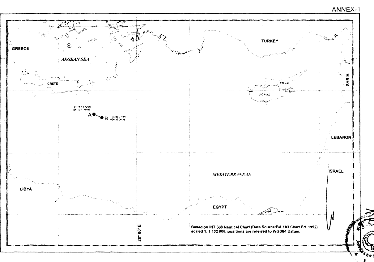
How were the endpoints chosen? Annex II lists eighteen coastal base points for Türkiye and eighteen for Libya. Measurements on WGS84 from A to the nearest listed point on either side give 152.9 nautical miles to Turkish point 2 and 153.2 to Libyan point 18. B lies 154.9 nautical miles from Turkish point 3 and 155.2 from the same Libyan point 18. At both ends the difference is under half a nautical mile. Those distances derive directly from Annex II. The Greek coasts that Athens says should count are absent from its lists. The calculation establishes one precise fact. Both endpoints are very nearly equidistant from the listed Turkish and Libyan base points. Why the Greek islands should alter that calculation, and to what extent, is a separate legal question. [3, 27]
Libya itself had already put the effect of islands before the International Court of Justice. In the case between Libya and Malta, the Court shifted the provisional median line towards Malta to take account of Libya’s much longer coast. In the Channel, the British islands off the French coast likewise failed to draw the Anglo-French boundary towards them along its entire length. For the Tripoli line the lesson is specific. The presence of a Greek island on a chart cannot, of itself, rule out an overlap between entitlements projected by Anatolia and Libya. Taken together, the two decisions undermine Athens’ contention that a Greek island necessarily cuts off the relationship between the mainland coasts wherever such an island lies. [28, 29, 30, 25]
Athens’ final argument invokes the principle governing third states. Greece is correct that the Türkiye–Libya agreement cannot bind it without its consent. The principle works both ways. Athens and Cairo have no power to apportion Türkiye’s continental shelf on its behalf. A neighbour’s objection alone does not extinguish an agreement between its parties. In the Libya–Malta case, the Court limited the geographical scope of its ruling in light of Italian claims and still delimited the shelf between the two parties. Protecting a third state’s rights and establishing a boundary between two coastal states are compatible. Athens thus invokes the very principle on which Ankara relies in defending the A–B segment. [3, 2, 31, 32, 23, 28]
A second Greek objection concerns the power to sign for Libya. The signatory was the Government of National Accord, the government with which the UN dealt. Tripoli told the UN that talks had begun in 2007, broken off in 2014 and resumed in June 2018. Athens invokes Article 8(2)(f) of the 2015 Libyan Political Agreement, which requires the endorsement of the House of Representatives for international agreements. Tripoli replied that its government had authority under Libyan law to conclude and approve a memorandum of understanding. According to Ankara and Tripoli, the memorandum entered into force on 8 December 2019. It was registered with the UN on 11 December. Libya’s own legislature would later address its earlier rejection. [26, 4, 33, 27]
On 20 October 2026 the Libyan House of Representatives voted unanimously to endorse the maritime memorandum it had opposed in 2020. Decisions Nos. 13 and 14 were drawn up in Benghazi on 22 October and published in the Official Gazette dated 15 November. The first rescinded the earlier rejection, the second the decision to sever political relations with Türkiye. Athens reiterated its objections on 20 October. There is now no documentary basis for presenting the rejection that Libya’s parliament withdrew as the position that parliament holds today. The European Union and Egypt may maintain their own objections. The vote in the Libyan legislature was Libya’s to take. [34, 35, 36, 22, 37, 38]
In 2022 Athens sent the UN a further objection, this time to the hydrocarbons cooperation instrument Türkiye and Libya had signed on 3 October. Greece opposed that text insofar as it directly or indirectly implemented the 2019 memorandum, which Athens maintained had no legal effect. Ankara distinguishes the two instruments. The first established the A–B boundary. The second provided a framework for scientific, technical and commercial cooperation on land and at sea. Does that framework itself authorise drilling in an area where Greek rights have been established? It does not. Does Libya therefore need Athens’ approval to cooperate with Türkiye on its own territory? It does not. The strength of the Greek objection depends on which activity it addresses and where. [39, 40, 4, 3]
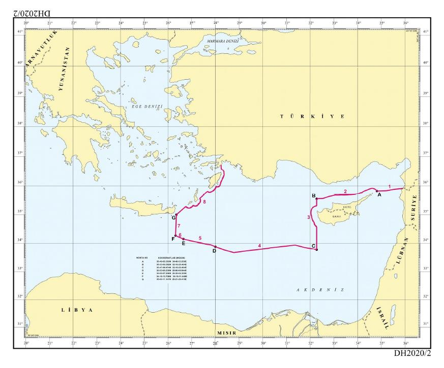
The charts tell the same story. Türkiye’s general chart submitted to the UN in March 2020 labels the memorandum’s points A and B as F and E respectively. The letters belong to different documents. The coordinates coincide. Libya’s 2025 UN communication and Türkiye’s response also record both states’ support for the line. Article IV provides for cooperation over resources that straddle the boundary. A party negotiating an EEZ boundary with a third state must notify and consult the other party before concluding an agreement. The practical point is that Türkiye defended its shelf through an agreement with a coastal neighbour and left room for subsequent talks. Greece’s consent is required for an agreement to bind Greece. Ankara and Tripoli need no Greek authorisation to uphold the boundary they agreed between themselves. The same distinction comes into sharp focus off Kaş, opposite Meis. [3, 12, 4, 41]
Meis has a coast. What about Kaş?
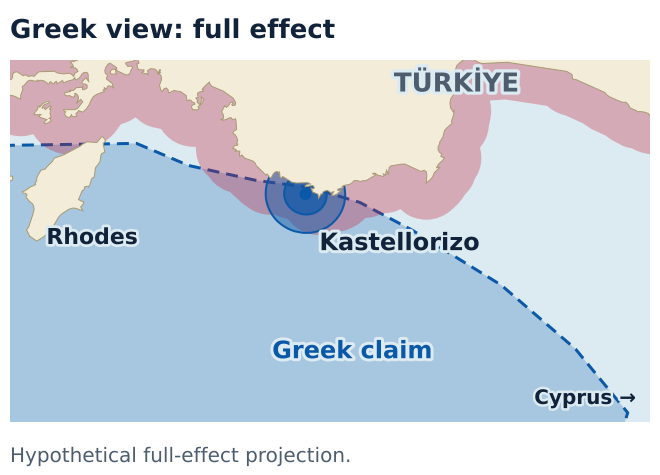
Greece’s foreign ministry presents continental shelf delimitation as an issue solely between the Greek islands facing Türkiye and the Turkish shore. Meis, also known as Kastellorizo, is a Greek island. Greek sovereignty over Meis does not make that island the sole measure of the shelf to which the Turkish coast is entitled. The island’s municipality places it about 1.25 nautical miles from Anatolia and about 72 from Rhodes. Kaş is more than a point on a navigational chart. Türkiye has an inherent continental shelf entitlement by virtue of that coast. It is possible to respect the island’s territorial sea and preserve the Turkish coast’s projection towards the more distant seabed. International practice provides several examples. [10, 18, 9, 25]
Picture a fishing boat passing Kaş. The water may look the same in every direction, yet the legal questions change with the activity. The vessel’s passage is governed by navigation rules, its nets by fisheries jurisdiction, and drilling hundreds of metres below it by rights over the seabed. In the territorial sea a coastal state’s sovereignty extends to the water, the bed and the air above. Continental shelf rights over resources arise without proclamation. An EEZ also covers resources in the water, including fish. The fact that Meis has a territorial sea does not establish Greek rights to a distant gas field off the island. [11, 42]
The UN Convention on the Law of the Sea addresses the two questions in different articles. Article 121 describes the zones an island may generate. Articles 74 and 83 require delimitation between opposite or adjacent coasts to achieve an equitable result in the EEZ and on the continental shelf. Türkiye is not a party to the Convention. Customary rules and the judgments explaining them nevertheless concern both countries. Greece itself illustrated the distinction in its 1976 application. It asked the Court first to recognise the shelf entitlements of named islands, and then to determine the boundary. A state that had to ask the second question cannot treat its answer to the first as a settled line off the Turkish coast. [11, 43, 7]
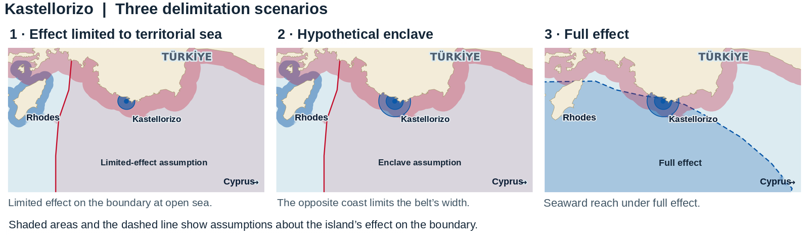
Do courts really answer the two questions separately? In Bangladesh v. Myanmar, the inhabited Bangladeshi island of St Martin’s had an economy of its own and lay close to the coast of Myanmar. The International Tribunal for the Law of the Sea first delimited the territorial seas and gave the island full effect there. Farther offshore it gave the same island no effect on the boundary. Population and island size did not decide the offshore boundary. Giving the island effect there would have cut off the seaward projection of Myanmar’s mainland coast. [44, 10]
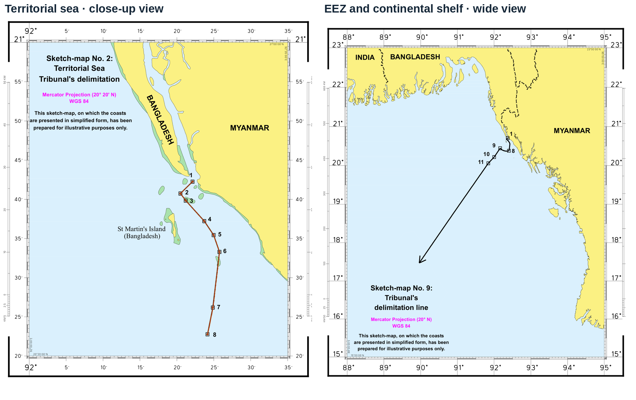
That is the difficulty with demanding full effect for Meis. Settlement helps establish that an island can generate entitlements. It cannot justify every offshore line that cuts off the projection of an opposing coast. St Martin’s received full effect in the territorial sea and none on the EEZ and continental shelf boundary. The Turkish case for Kaş rests on the same distinction. The territorial sea around Meis can be respected while the continental shelf extending farther offshore from Anatolia is taken into account. Ownership of the island need never enter that argument. [44, 9, 12]
There is a further choice to make. From which points should the distances be measured? In its September 2025 note to the UN, Greece measured its provisional median line from base points on the islands it considered relevant. Each party may propose base points. Neither can impose its selection on the other. In Romania v. Ukraine, Ukraine asked the Court to use Serpents’ Island, off the mouth of the Danube. In 2009 the Court declined. The island would have added an artificial spur to Ukraine’s mainland coast and pushed the line towards Romania. Its twelve-mile territorial sea survived, and the offshore line was calculated from points elsewhere. For the same reason, Türkiye is under no obligation to accept every island headland chosen by Athens as a base point for delimiting the Turkish shelf. [9, 43, 45]
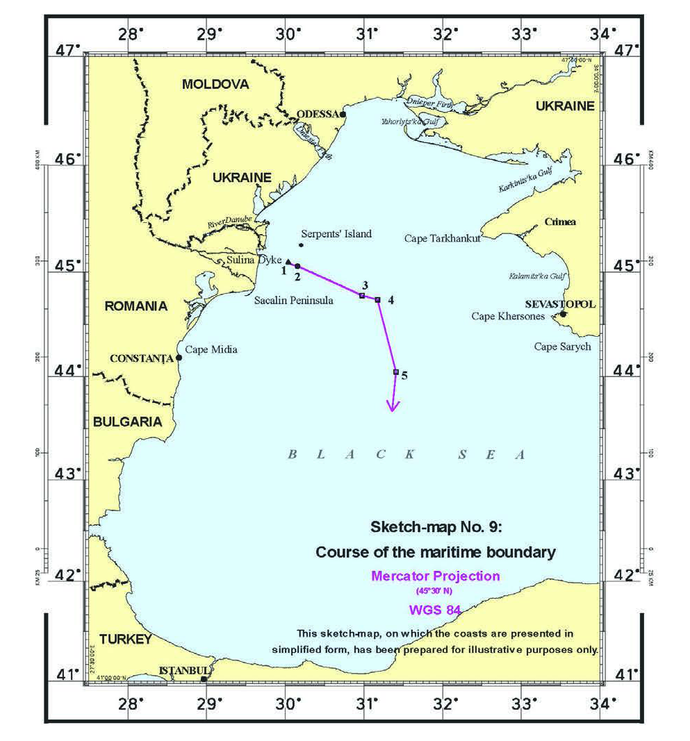
Comparing the population of Meis with that of Serpents’ Island would miss the issue. The Court reached its decision without deciding whether the island fell within the Convention’s exception for rocks. A feature’s entitlement and its suitability as a base point are distinct questions. The 2016 South China Sea arbitration addressed the first. On an application by the Philippines, the tribunal examined whether features in the Spratly Islands in their natural condition could sustain human habitation or economic life of their own. Installations built later and supplies brought in from outside could not establish natural capacity. None of the high-tide features examined generated an EEZ or continental shelf of its own. [43, 11, 46]
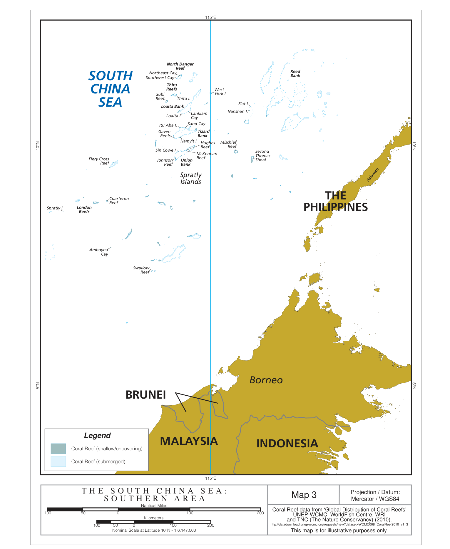
The South China Sea award refutes a further assumption in Athens’ map. Only some features above water can generate a 200-nautical-mile exclusive economic zone of their own. When a rock is invoked in the Aegean, the first question for Ankara is what entitlement it can generate in its natural condition. The Turkish case concerning Meis can proceed without that inquiry. Off Kaş the issue is the effect of an acknowledged island on the boundary. The decisions concerning St Martin’s and Serpents’ Island support Türkiye’s objection on that ground. A Greek chart that gives every rock the same treatment as every island fails both tests. [46, 47, 44]
Italy and Tunisia settled this issue by negotiation. In 1971 they drew the general median line in the Strait of Sicily without using Pantelleria, Linosa, Lampedusa or Lampione as base points. They then delimited the seabed around the islands, drawing a twelve-mile arc for Lampione and thirteen-mile arcs for the other three. Each arc met the general line or the neighbouring arc as the geography required. The four Italian islands retained surrounding seabed without moving the boundary of the entire strait towards Tunisia. The limited effect Ankara argues for off Meis has a counterpart in treaty practice. A demand to measure solely from Greek islands would impose on Türkiye a requirement that Italy itself did not accept for its own islands. [48, 49, 10]
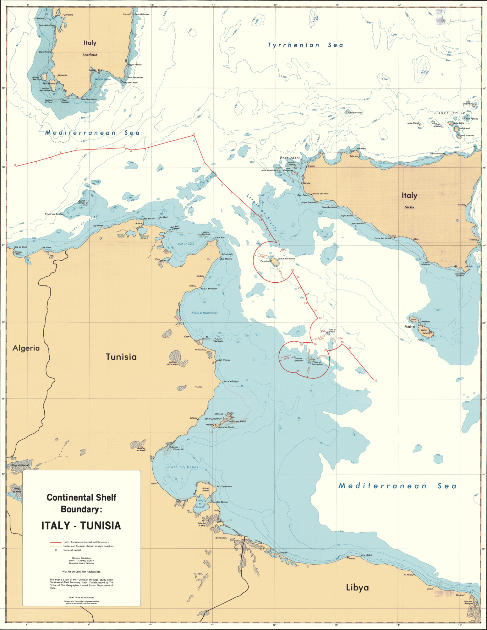
The geography worked differently in the Saint-Pierre and Miquelon arbitration between France and Canada. The French islands lie just south of Newfoundland. In 1992 the tribunal drew a 24-mile arc around them on the western side. To the south it found no Canadian coast wholly blocking their projection and awarded France a corridor about 10.5 nautical miles wide. If Athens claims the same breadth in every direction from Meis, it must show why every side of the island warrants that result. The same French islands produced different outcomes to the west and to the south. [50, 51, 52]
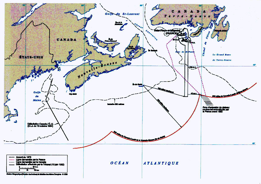
The northern face of Meis looks straight at Anatolia across the water from Kaş. On the island’s other side the arrangement of coasts is different. Türkiye is entitled to have each direction examined on its own terms. A southward corridor for French islands off Newfoundland supplies no ready-made corridor off Kaş. St Martin’s, Serpents’ Island, the Strait of Sicily and Saint-Pierre illustrate the range. An island can belong to the same state throughout and still count for less offshore, have no effect on a line, or retain a projection in a particular direction. Ankara rejects the premise that Athens can settle the outcome before the calculation has begun. How does Crete, farther west, change the calculation? [50, 44, 18]
What does Crete’s coast establish for Meis?
Crete is Greece’s strongest geographical argument against the agreement with Libya. Athens observes that Crete’s southern coast faces Libya and argues that the Turkish–Libyan line intrudes on Greek maritime rights. Crete plainly has a coast facing the open sea. In law, that coast must be taken into account in the direction it faces. But extending an unbroken Greek shelf off south-western Anatolia by linking Crete, Kasos, Karpathos, Rhodes and Meis requires another argument altogether. The first proposition does not establish the second. Ankara is right to argue that the effect of a large island and that of a small island immediately off the Turkish shore must be assessed separately. [22, 23, 25, 28]
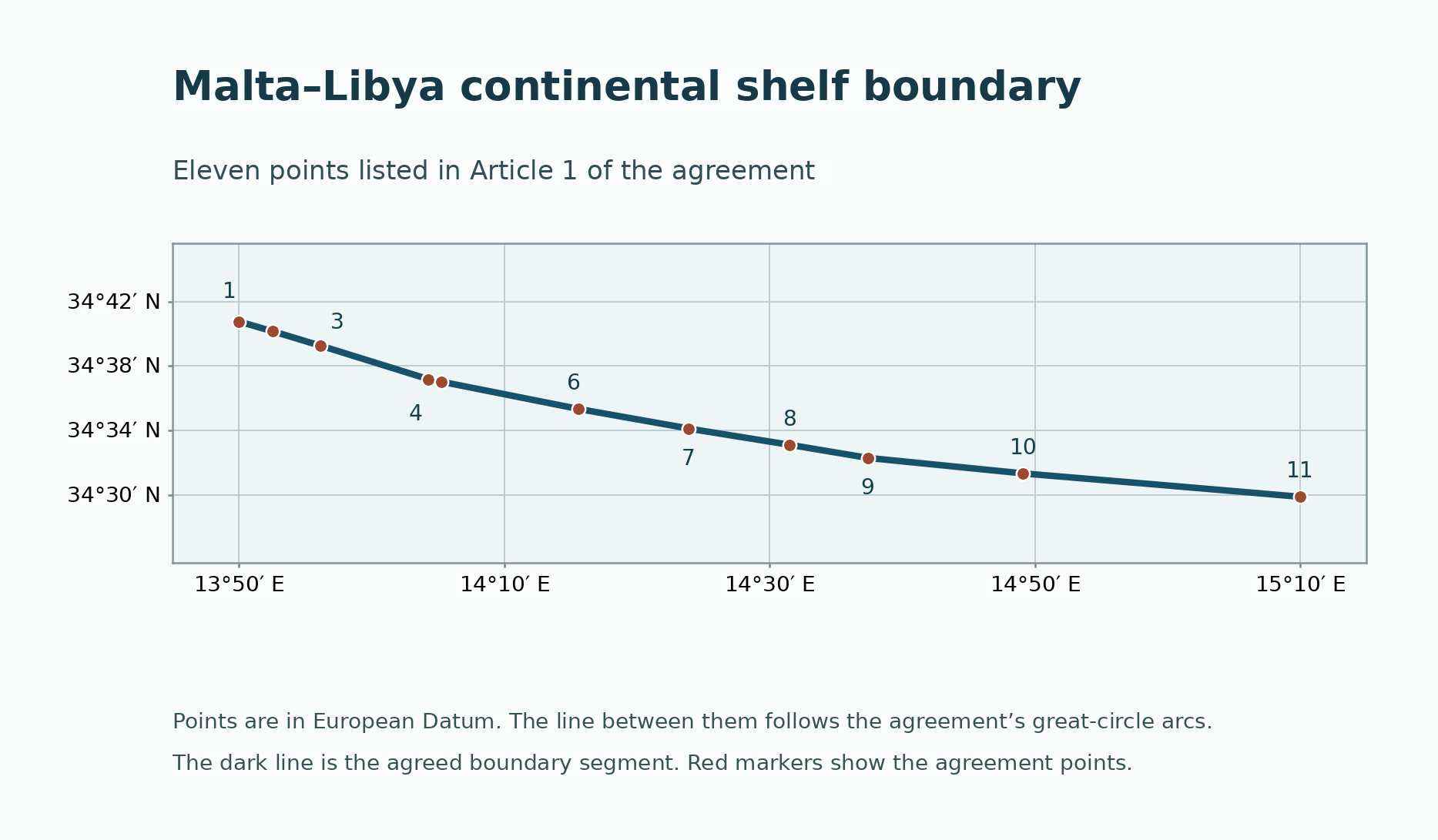
Malta makes the distinction particularly clear because the islands there constituted a state. In 1985 the Court left the tiny islet of Filfla out of its calculation and constructed a provisional median line. It then took Libya’s much longer coast and the regional geography into account and shifted the line north towards Malta by about eighteen minutes of latitude. Even an independent island state could not cancel the significance of a long coast opposite. Greek title to Crete therefore does not establish where entitlements projected by Anatolia and Libya must end. [28, 29, 25]
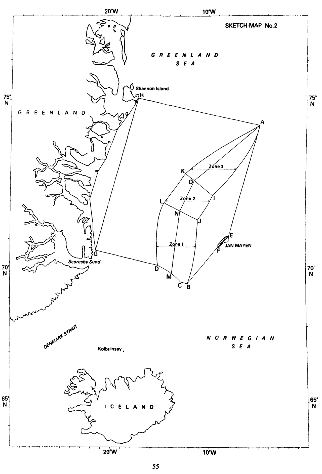
In the North Atlantic, Norway argued for the median line between Greenland and Jan Mayen. Denmark invoked Greenland’s much longer coast. In 1993 the Court shifted the provisional line eastward in favour of the longer coast and, in the southern sector, took account of access by both parties to the migratory capelin fishery. Coast length supplied no automatic distribution of sea area. It did show what the initial line cost each side. Athens cannot dismiss the corresponding disparity in coastal lengths off Anatolia as immaterial. Türkiye has ample judicial authority for asking that the length of its coast be considered. [53, 54, 43]
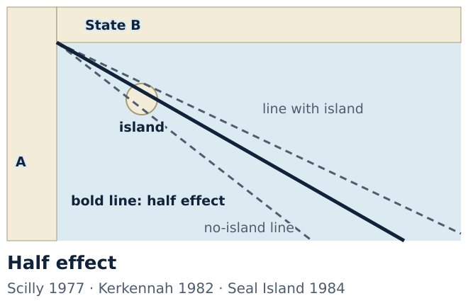
The 1977 Anglo-French arbitration offers an especially close comparison. Jersey and Guernsey, off the French coast, were under British sovereignty. The tribunal first established the general line between the two mainland coasts in the Channel. To the north and west of the islands it left them a twelve-mile belt of continental shelf. The Isles of Scilly, off Britain’s western end, received half effect between a line giving them full weight and a line disregarding them. Ankara cites the award at the UN for good reason. In a single dispute the tribunal made two different calculations for two British island groups. Türkiye’s demand that the islands facing its coast be examined individually has a clear precedent. [30, 55, 4]
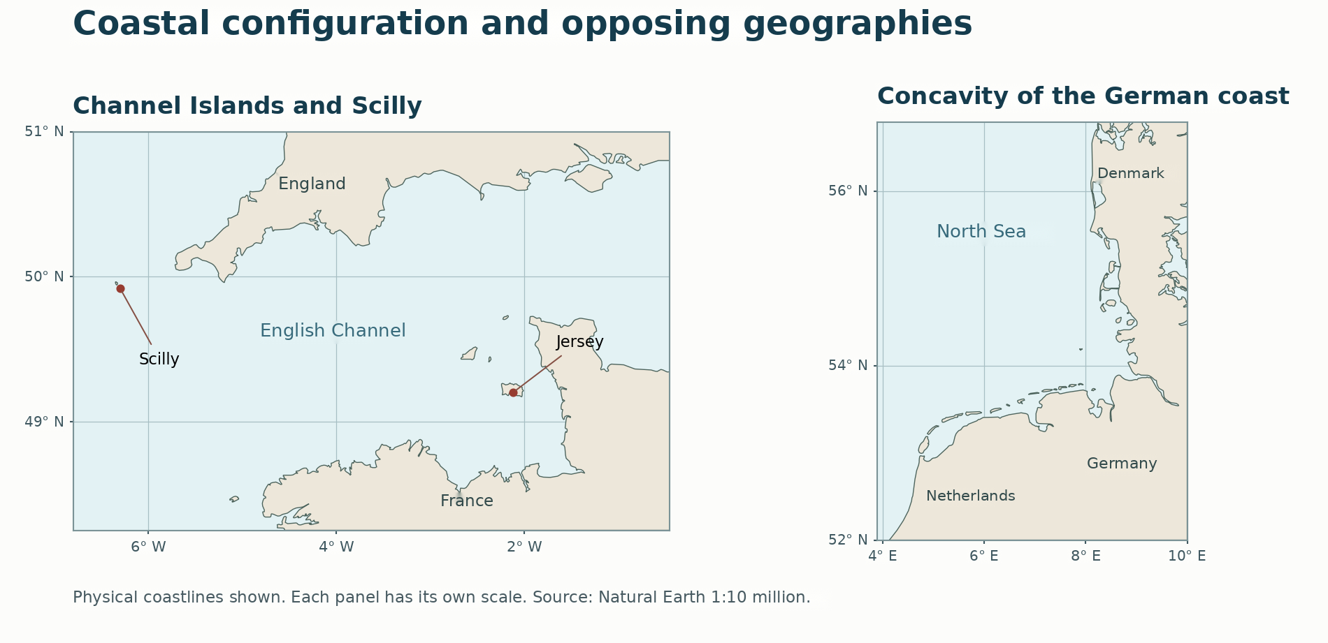
The right-hand panel illustrates another complication. Germany’s North Sea coast curves inward between the Netherlands and Denmark. Lines drawn separately at equal distances from each neighbour converged in front of Germany. In 1969 the Court found no customary obligation on Germany in that dispute to accept equidistance. It required the three states to negotiate in light of natural prolongation and equitable principles. The Aegean coast need bear no likeness to Germany’s for the point to hold. Ankara’s point is that the same geometric operation can cut off one coast disproportionately. Where Türkiye demonstrates such a cut-off, saying that both sides were measured with the same ruler leaves its legal objection unanswered. [55, 57, 43]
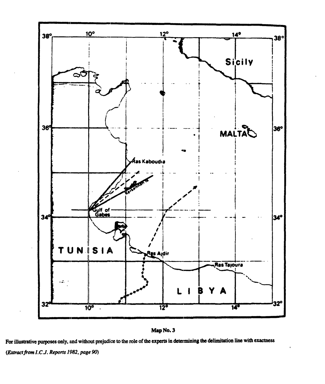
What does ‘half effect’ actually halve? In Tunisia v. Libya the coast changed direction near the Gulf of Gabès. Including the Kerkennah Islands yielded one bearing, and leaving them out yielded another. In 1982 the Court bisected the angle between the two for the second sector, obtaining a bearing of about 52 degrees. It had adjusted the angle of one line. Neither title to territory nor a state’s entire maritime share was halved. Türkiye can therefore argue for a corrected bearing in the Aegean while leaving Greek ownership of an island entirely intact. [58, 59, 1]
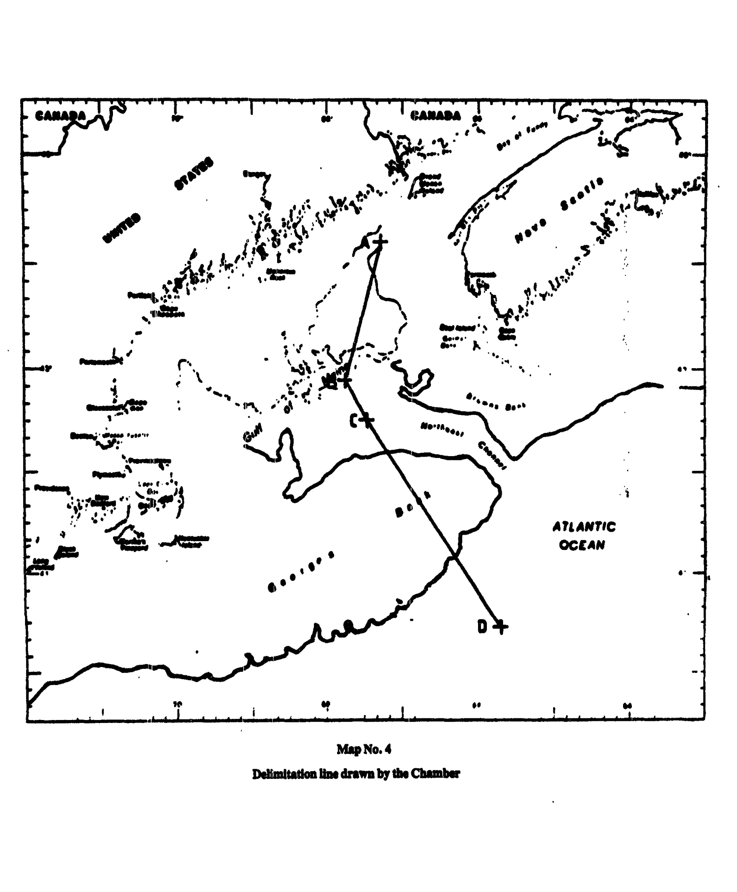
In the Gulf of Maine, the United States and Canada wanted a single line for fisheries and the seabed. In 1984 a Chamber of the Court divided the boundary into three segments. In the middle segment, giving Seal Island full effect brought the line too close to the United States. Leaving it out discounted the Canadian coast too heavily. The Chamber gave the island half effect in that segment alone. Kerkennah involved two bearings, Maine the weight of an island in one calculation. The Turkish objection concerning Rhodes or Meis does not require importing a percentage from a foreign judgment. As judicial practice shows, Türkiye makes a concrete request when it asks what effect measuring from a particular island would have on the Anatolian coast. [59, 57, 30]
A leading Caribbean decision shows how both coasts can be given effect in the same delimitation. Colombian islands including San Andrés and Providencia lie off Nicaragua’s long coast. In 2012 the Court preserved their eastward projection. On their western side, however, the provisional line cut too deeply across Nicaragua’s seaward reach. The Court gave the selected Nicaraguan base points a weight of three and the Colombian ones a weight of one. It allowed only twelve-nautical-mile belts around remote Quitasueño and Serrana. The large Colombian islands retained a maritime projection, and the mainland coast also received its due. The three-to-one ratio describes the weight of the selected base points. The distribution of maritime areas was a separate result. [52, 45, 50]
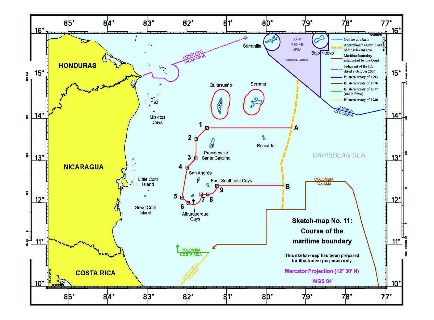
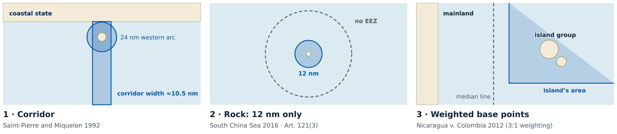
Nicaragua v. Colombia supplies a test for both Crete and Meis. The east-facing coasts of the large Colombian islands retained access to open water, while the two small outlying features received only their territorial-sea belts. Türkiye relies on the same principle. Crete’s genuine seaward projection does not give Meis the same effect. The larger island’s entitlement cannot justify allowing the smaller island to cut off the coast at Kaş. This is the calculation missing from a Greek objection that would dismiss the entire Turkish–Libyan line. Beyond the courtroom, Greece has also advanced its position through a national map. [11, 44, 52, 4]
Can a Greek planning map set a neighbour’s boundary?
When draft legislation on maritime jurisdiction was discussed in Ankara, the Greek foreign minister observed that one state’s law could not draw a boundary involving more than one state. The point is sound. It applies equally to the maritime spatial plan Greece published in 2025. Athens can tell its own officials where it plans to allow particular activities. A Greek ministry’s seal cannot determine where Türkiye’s continental shelf ends. The minister’s answer to the proposed Turkish law makes a succinct response to the Greek plan. [9, 60, 61, 4]
Greece’s own September 2025 note to the UN bears this out. Section D explains the map legend. Section E describes a provisional median line measured in part from ‘relevant’ Greek islands, pending agreements with neighbouring states. The boundary agreed with Italy and the provisional line drawn pursuant to Greek legislation have different legal standing. Libya objected to parts of the Greek plan in its own 2025 note. Where three coastal states have expressed distinct positions, the official gazette of one cannot stand in for the signatures of the other two. [9, 10, 60, 41]
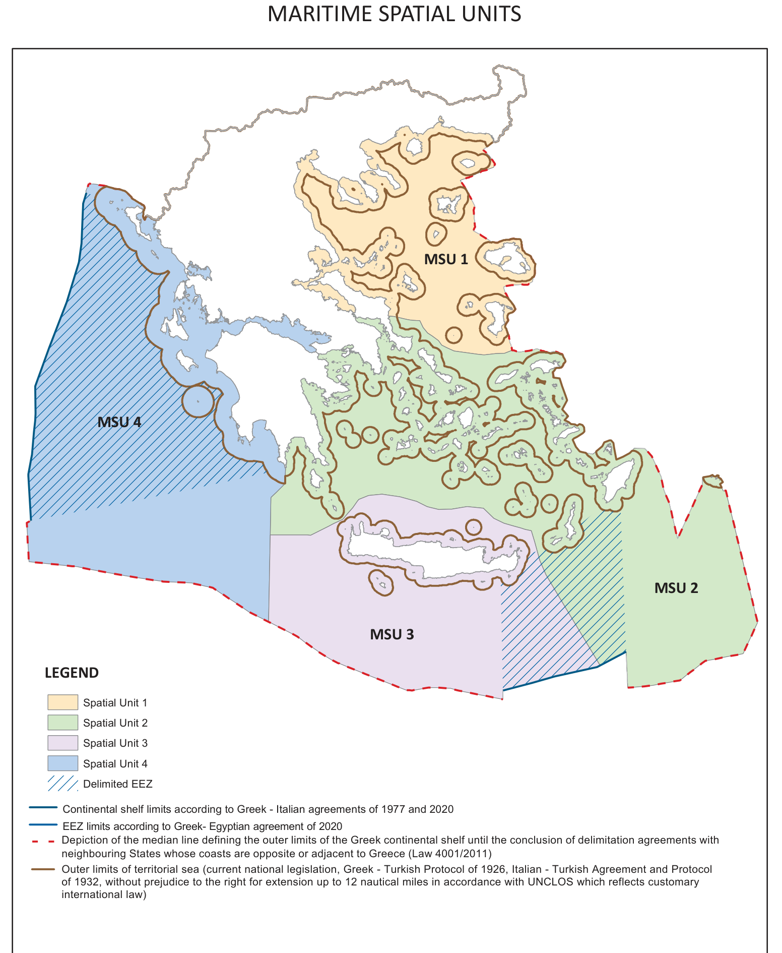
Article 2 of the European Union’s Maritime Spatial Planning Directive expressly reserves the delimitation of maritime boundaries. A plan submitted in Brussels carries no international approval of the line it depicts. Somalia v. Kenya illustrates the evidentiary threshold. Kenya relied on proclamations and conduct to claim a boundary along a parallel of latitude and argued that Somalia had acquiesced. In 2021 the Court found that silence and unilateral acts did not establish the boundary claimed in that case. The conclusion is stronger still for Türkiye, which expressly protested the Greek plan. Its consent cannot be inferred from a Greek chart. The much-discussed Seville map is an academic work. Türkiye’s own planning map likewise records its administrative choices and claims. [62, 63, 64, 65, 66]
In August 2026 the dispute reached marine parks. The Greek foreign ministry said that Turkish parks extended into Greek jurisdiction and that the Greek parks stayed within Greek territorial waters. A designation made for conservation cannot settle an underlying dispute over jurisdiction. In the 2007 Guyana–Suriname arbitration, the tribunal emphasised the duty to seek interim arrangements in good faith and to avoid jeopardising a final agreement. The award illustrates why neither state can use force or unilateral economic measures to defeat its neighbour’s rights pending delimitation. It is on this distinction that Türkiye bases its objection to imposing a boundary through a protected area. A NAVTEX navigational warning has a different function again. The transmitting station acquires neither title to an island nor a seabed drilling licence. [67, 68, 69, 70, 71]
The colours on the Greek plan now take their proper place. An agreed boundary records the consent of two parties. A national plan, a marine park decree or a navigational warning records an act of the authority that issues it. Türkiye is entitled to reject any attempt to give those instruments binding effect on the rights generated by its coast. The territorial sea makes the stakes more tangible. For a ship leaving a Turkish port, a change of colour on the chart can mean a change in the law governing the passage. [12, 63, 72]
Do twelve nautical miles settle how to divide the Aegean?
Greece’s foreign ministry says that any coastal state may extend its territorial sea up to twelve nautical miles and that Greece reserves the choice of when and where to exercise that right. Both countries currently apply six nautical miles in the Aegean. In 2021 Greece extended its territorial sea to twelve miles in part of the Ionian Sea. The distinction between these two seas matters. Twelve miles is the permitted maximum breadth. It does not settle boundaries between interlocking islands and opposite coasts. Ankara objects to a unilateral extension beyond six miles in the Aegean because of its effects on the balance of interests, maritime access and Türkiye’s own coastal rights. [72, 73, 11, 74]
Consider two straight coasts eighteen nautical miles apart. If each state claims twelve miles, the middle six are claimed twice. In the absence of an agreement, historic title or a special circumstance, the median line in this example lies nine miles from each coast. Article 3 of the Convention sets the maximum breadth. Article 15 addresses the delimitation of the territorial seas of states with opposite or adjacent coasts. Athens invokes Article 3 when it asserts a right to twelve miles. Ankara points to Article 15 when it asks how far that entitlement can extend opposite the Turkish shore. [11, 75, 76]
The Turkish foreign ministry has calculated the effect of both states applying the same breadth. An increase from six to twelve nautical miles reduces the share of the Aegean outside territorial seas from 48.9% to 19.7%. Greece’s share rises from 43.6% to 71.5%, Türkiye’s from 7.5% to 8.8%. These are scenario calculations. The same six-mile extension would add more than a quarter of the sea to Greece’s share, against an increase of just 1.3 percentage points for Türkiye. A formally equal entitlement thus produces sharply unequal effects. Türkiye must therefore ask that the routes on which freedom of navigation would be curtailed, and the passage regimes that would apply there, be identified in advance. [77, 11, 72]
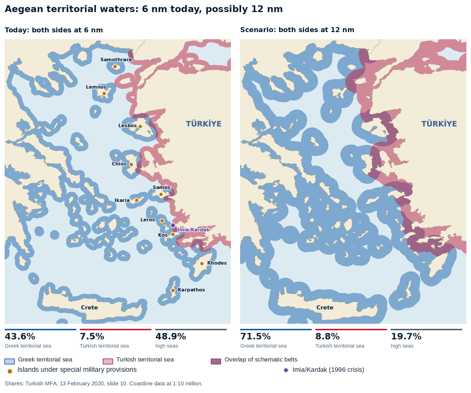
Would the change exclude ships from the Aegean? No. Innocent passage applies in territorial waters, with distinct passage regimes for qualifying international straits. In the Corfu Channel case, Albania expected British vessels to seek prior authorisation to pass through the northern channel. In 1949 the Court held that such permission was unnecessary for innocent passage in peacetime through that strait, which connected two parts of the high seas and was used for international navigation. The Corfu ruling does not automatically apply to every narrow passage in the Aegean. Even an extension of the territorial sea would give Greece no unrestricted discretion over maritime traffic. Türkiye may legitimately assert passage rights on particular routes. [11, 72, 78, 32, 79]
Athens invokes the UN Charter and characterises the reference to military powers in the Turkish parliament’s declaration of 8 June 1995 as a threat of force. The declaration addressed what Ankara saw as a threat to Türkiye’s vital interests and to the existing balance in the Aegean. The legal characterisation of the declaration and the effect of a unilateral extension on passage routes merit separate examination. A coastal state has grounds to raise concerns about access to the open sea. Saying ‘twelve miles’ does not settle those concerns. The mutual recognition of vital interests in Madrid gives them political expression. The contrast becomes still sharper above the water, where Greece claims ten miles of national airspace. [72, 78, 32, 80]
A six-mile territorial sea. Why ten miles of airspace?
The Greek foreign ministry offers two grounds for the ten-mile national airspace proclaimed under the 1931 aviation decree. Ten miles falls within the twelve-mile breadth Greece could claim at sea, and Türkiye, it says, did not object for many years. Consider a point eight nautical miles from the nearest Greek baseline and outside the territorial sea of any other state. A ship at that point lies beyond Greek territorial waters. On what basis should the civil aircraft directly overhead be treated as having entered Greek territory? The first justification finds no support in the Chicago Convention. This four-mile difference is the substance of Türkiye’s objection. [81, 82, 83]
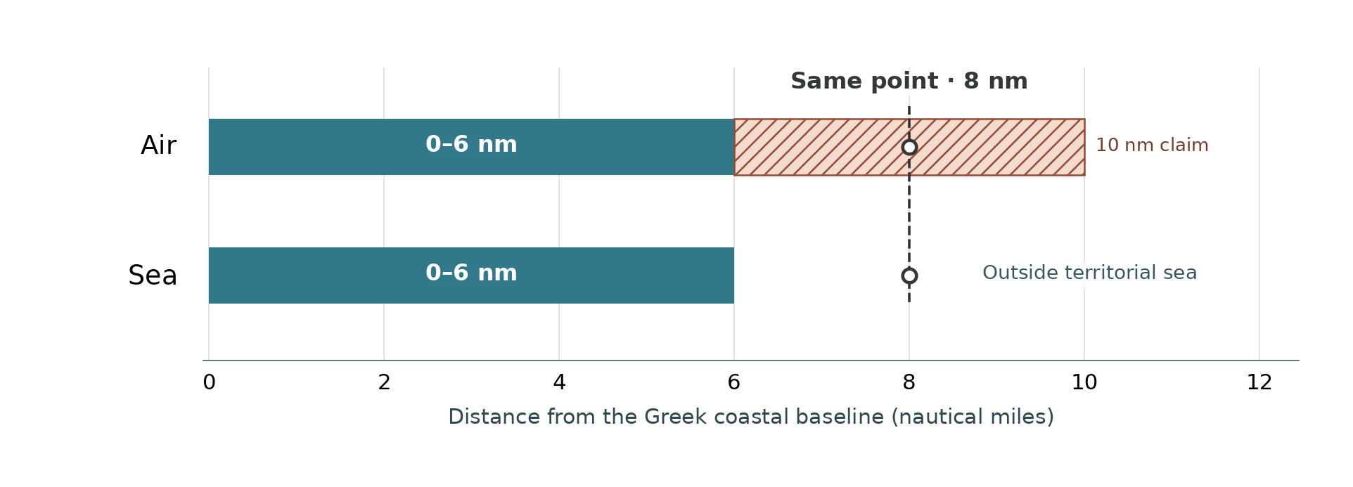
Articles 1 and 2 of the Chicago Convention relate air sovereignty to land territory and the adjacent territorial waters. Article 2 of the Law of the Sea Convention makes the same connection. A possible future extension cannot establish a present territorial sea. Indeed, Greece describes the airspace in the extended Ionian sector as reaching twelve miles along with the waters below it. So long as its Aegean territorial sea remains at six miles, Athens cannot derive the additional four miles of airspace from those same instruments. In Ankara’s view a national decree cannot require Turkish civil or state aircraft to treat that band as Greek territory. Overflight of a Greek island or its territorial sea raises a separate legal question. [83, 11, 81, 73]
Greece’s second argument is acquiescence. In the Temple of Preah Vihear case between Cambodia and Thailand, the Court examined when Thailand received a particular map, how its officials acted and what their subsequent conduct showed. Elapsed time alone did not decide the case. Likewise, the publication date of a Greek decree establishes no particular act by which Türkiye accepted a ten-mile limit. A recorded US protest in 1994 also contradicts any claim that the four-mile band enjoys uncontested international acceptance. Given Türkiye’s express objection, recording every flight in the disputed band as a violation of a settled boundary is legally misleading. [81, 84, 85]
The distinction affects the figures reported in public. An unauthorised flight over a Greek island raises a question of Greek territorial sovereignty. Classifying a flight eight miles off that same island as a ‘violation’ on that ground assumes the validity of Athens’ disputed ten-mile claim. Adding both to one total makes a contested legal question appear settled. Türkiye should ask for each incident to be assessed by its coordinates and the legal regime applicable at that point. [81, 83, 86]
Greece’s own account of the Athens Flight Information Region (FIR) acknowledges that it extends in part over international airspace. An FIR assigns responsibility for air traffic information and safety services. It does not define national sovereignty. Greece also seeks flight plans from military aircraft entering the region. Türkiye relies on Article 3 of the Chicago Convention, which treats state aircraft separately. Both states remain under a duty to have due regard for the safety of civil aviation. Safety coordination gives Athens no sovereign power to authorise passage through international airspace. [86, 83, 87, 74]
A similar distinction arises at sea. Greece argues that its island-based rescue centres are well placed to respond and treats the apparent inclusion of Greek islands on Türkiye’s rescue chart as a sovereignty issue. Paragraph 2.1.7 of the annex to the 1979 Search and Rescue Convention makes clear that designating search and rescue regions does not determine state boundaries. When a vessel is in distress, coordination should allow the centre able to reach it to act without delay. Turkish rescue capacity and responsibility imply no claim to a Greek island. Equally, Greek coordination of a rescue confers no title to the waters involved. At Kardak, by contrast, title to the land itself is the issue. [87, 88, 89, 74]
Which document completes the chain of title to Kardak?
At the end of December 1995 a Turkish freighter grounded on the Kardak rocks, bringing the two states to the brink of a crisis. Greece’s foreign ministry maintains that international treaties clearly settle their ownership. Its strongest evidence is point 30 of the instrument of 28 December 1932, which refers directly to the rocks. Türkiye’s challenge concerns that very document. By what legal act did the December text acquire the force of the earlier agreement signed in January and subsequently ratified? Neither state’s records identify a legal act on which the two states agree. That gap is the basis of the Turkish challenge to Greece’s chain of title. [47, 90]
Greece also invokes distance. Unless otherwise provided, Article 12 of Lausanne leaves to Türkiye islands within three miles of the Anatolian coast. Athens draws the reverse inference from the 3.7 miles it gives as Kardak’s distance from the Turkish shore. A rule for islands inside three miles does not allocate each rock on the other side. Article 15 deals with the islands and dependent islets ceded to Italy, while Article 16 addresses Türkiye’s renunciation of rights in other territories. In 1947 Article 14 of the Paris Treaty ceded the Dodecanese and adjacent islets to Greece. An islet can pass with a group without being named. Athens must then establish that these two rocks belonged to the group that passed to Italy. A distance and a general renunciation cannot do all the evidentiary work. [91, 92, 47, 90]
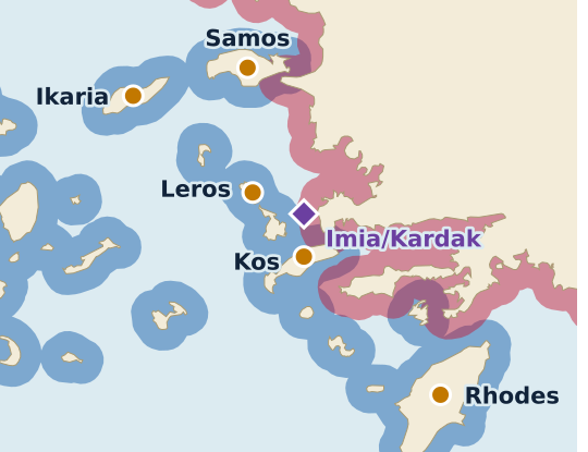
The sequence of documents matters. The Turkish–Italian convention of 4 January 1932 was ratified and registered with the League of Nations. It concerns islands and waters near Meis and also Kara Ada off Bodrum. The direct reference to Kardak occurs in point 30 of the text of 28 December. Greece reads the point as lying between Kardak and Kato on the Anatolian side, leaving Kardak on the Italian side. Ankara argues that the separate legal formalities were not completed and that the December instrument was never registered. The Turkish foreign ministry also notes that Italy raised the question of approval again in 1937. Athens regards the later act as the technical implementation of a boundary already in force. The registration number of the January convention cannot by itself answer the objection to the December text. [93, 47, 90]
What weight can signed but unregistered minutes carry? In Qatar v. Bahrain the Court held in 1994 that the Doha minutes signed by the two foreign ministers created specific obligations. The title of a document therefore cannot settle Kardak either way. Ankara cannot dismiss the instrument of 28 December simply because it was called a record. Nor can Athens infer a binding cession solely from the description of a line. What authority did the signatories have? Did they identify the area of an earlier agreement or enlarge it? These questions turn on authority and scope. In the absence of a shared answer, the document cannot sustain Greece’s assertion that no dispute exists. [47, 90, 94, 95]
There remain the historical maps. In the Burkina Faso/Mali frontier dispute, the Court explained that maps usually serve as supporting evidence. A map forming part of a treaty and expressing the parties’ will may carry greater weight. The old Italian charts cited by Athens may thus have evidentiary value. On their own they cannot establish that the disputed instrument was ratified. Ankara maintains that the two Kardak rocks belong to Türkiye and that no treaty transferred them. A unilateral Greek chart cannot settle that claim. Türkiye accepts Greek sovereignty over the large islands expressly ceded to Greece. For those islands a different question arises. What obligations do the military restrictions accepted at the time of cession impose today? [94, 96, 47, 90, 151]
Can Athens accept the cession and disregard its terms?
The Greek foreign ministry recognises three distinct military regimes in the eastern Aegean. It also invokes the threat it perceives from Türkiye and the right of self-defence under Article 51 of the UN Charter. Ankara’s letter of 13 July 2021 to the United Nations sets out the Turkish position. The cession of the islands immediately opposite Anatolia was accepted subject to the security conditions laid down in the relevant treaties. Each island group must be examined under its own instrument. A general appeal to defence needs cannot insert a common exemption into three different treaties. As a party to Lausanne, Türkiye is entitled, in particular, to require Greece to fulfil the obligations it owes Türkiye under that treaty. [5, 97, 98, 99]
Article 13 of Lausanne governs Lesbos, Chios, Samos and Ikaria. It prohibits naval bases and fortifications. It also permits the normal contingent called up for military service to train on the islands and limits gendarmerie and police numbers by reference to the strength of those forces in Greece as a whole. Turkish military aircraft are not to fly over the islands, nor Greek military aircraft over the Anatolian coast. The provision allows some military personnel. Greece cannot turn permitted policing or conscript training into authorisation for a prohibited base or fortification. Türkiye’s objection is concrete and verifiable when it identifies the installation and the clause that governs it. [5, 91, 99]
Lemnos and Samothrace present a different question. Athens argues that the 1936 Montreux Convention replaced the 1923 convention governing the Straits. It cites a letter from the Turkish ambassador dated 6 May 1936 and Foreign Minister Tevfik Rüştü Aras’s parliamentary speech of 31 July. The protocol annexed to Montreux authorises Türkiye to remilitarise the Straits zone. It grants no corresponding authority in express terms for the two Greek islands. Athens therefore relies on interpretation of the diplomatic record to supply what the text leaves unstated. Even the broadest reading of those statements would leave intact Lausanne’s express ban on fortifications on Chios. Nor could statements made in 1936 set aside a Paris treaty provision on the Dodecanese adopted eleven years later, in 1947. [5, 97, 99]
For the Dodecanese, Greece invokes Article 14(1) of the 1947 Paris Peace Treaty as its title. The very next paragraph requires the islands to be and to remain demilitarised. Athens points out that Türkiye is not a party to that treaty. At most, that observation raises the question of which claims Ankara can bring directly under the Paris Treaty. It does nothing to extinguish the undertaking Greece itself signed. Athens also invokes changes in alliances and security conditions. A claim that a particular measure is necessary to meet a threat differs from a claim that a treaty obligation of indefinite duration has ceased to apply altogether. Athens identifies no amending treaty to establish the latter. Greece cannot invoke paragraph 1 as its title to the islands and disregard the continuing obligation of demilitarisation in paragraph 2. [5, 92, 97, 98, 32]
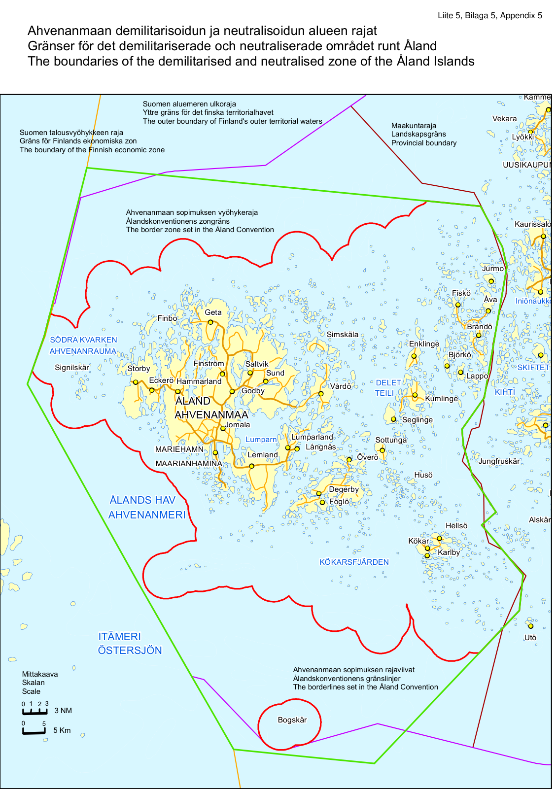
The Åland Islands in the Baltic provide a test. They belong to Finland, and a 1921 convention established restrictions on military facilities and a regime of neutralisation. Finland changed its defence alignment and joined NATO in 2023. Its NATO mission nevertheless reaffirmed the country’s commitment to Åland’s demilitarised and neutralised status. The geography and treaty language differ from the Aegean. The example defeats the broader Greek contention. Neither NATO membership nor a change in the threat is enough, on its own, to extinguish a special treaty regime for islands. Whenever Greece invokes security to justify a measure, Türkiye is entitled to invoke the treaty provision governing it. [5, 100, 101, 102]
Ankara’s 2021 letter takes the argument further. It contends that Greece’s continuing breach of an essential condition of cession precludes it from invoking the resulting sovereign title against Türkiye in maritime delimitation. Athens replied on 25 May 2022 by invoking Libya v. Chad, in which the Court held that a treaty boundary has a permanence independent of the subsequent fate of the treaty. That proposition leaves the continuing military obligation unanswered. A judgment about the permanence of a boundary cannot establish a right to disregard a security provision in the instrument of cession. Athens thus conflates two distinct legal consequences. Türkiye’s strongest claim is that Greece must comply with the treaty restrictions still in force. For as long as that demand remains unmet, Ankara maintains its further objection to Greece invoking the resulting title against Türkiye. East of the Aegean, in Cyprus, the connection between political authority and security has a longer history. [97, 98, 103, 91, 92]
Did the Cyprus question begin in July 1974?
Greece’s foreign ministry foregrounds the military events of July and August 1974 and the subsequent Turkish military presence. Its own historical account reaches much further back. Cyprus gained independence in 1960 as a constitutional partnership. A Greek Cypriot president and a Turkish Cypriot vice-president exercised specified powers in a system that assigned powers to both communities. Greece, Türkiye and the United Kingdom were its guarantors. Did Turkish Cypriots acquire the right to political partnership only in 1974? That right already belonged to them under a constitutional settlement Greece itself had signed. [6, 104, 105, 106]
In December 1963 a constitutional dispute turned into intercommunal violence. Athens says that Turkish Cypriots withdrew from state institutions. Ankara maintains that they were forced out of the constitutional partnership. One date stands under either account. In March 1964 the Security Council recommended the establishment of a peacekeeping force, which was deployed to the island. The UN had been on the ground for a decade by the time Turkish troops landed in July 1974. Any explanation that starts the entire security problem with those troops must first explain what brought the peacekeepers there ten years earlier. [104, 107, 105]
On 15 July 1974 a coup backed by the junta in Athens overthrew Archbishop Makarios. Four days later he directly accused the Greek military regime before the Security Council. Türkiye launched the Cyprus Peace Operation on 20 July. Ankara based its action on Article IV of the Treaty of Guarantee. It provides first for consultation among the guarantors and, where common action proves impossible, reserves to each the right to act for the sole purpose of restoring the order created by the treaty. The same instrument prohibited both union with another state and partition. Can the coup reasonably be dismissed as a pretext? The attempt to unite Cyprus with Greece was precisely the danger Greece had undertaken, as guarantor, to prevent. That is Ankara’s strongest historical and legal answer to Athens. [106, 108, 109, 105, 104]
Security Council Resolution 353 of 20 July called for a ceasefire, an end to foreign military intervention and the withdrawal of foreign military personnel present without the authority of international agreements. Reading it solely as an indictment of Türkiye omits the Athens-backed coup five days earlier and the security concerns Turkish Cypriots had faced since 1963. The Council’s text did not assign individual responsibility for the coup. Makarios’s testimony bears directly on that question. Greece can ask Ankara to account for its operation. It must also account for the role of its own junta in the events that preceded it. [106, 109, 107, 108]
Thirty years later both communities voted separately on the same UN settlement plan. On 24 April 2004, 64.9% of Turkish Cypriot voters approved it and 75.8% of Greek Cypriot voters rejected it. The Greek Cypriot side recorded its concerns about security, property and implementation. The Greek Cypriot electorate made its own decision to reject the plan. The question for Athens is whether Ankara and the Turkish Cypriots can invariably be blamed for obstructing a settlement. On that day Turkish Cypriots provided one of the two approvals the plan required. A week later, on 1 May, the Greek Cypriot Administration of Southern Cyprus joined the European Union. Protocol No. 10 to the Act of Accession suspended application of EU law where the government did not exercise effective control. EU accession could not supply the second community’s consent that the referendums had failed to secure. [6, 110, 111, 112]
Athens now advocates a bizonal, bicommunal federation with a single sovereignty and a single international legal personality. Security Council Resolutions 541 and 550 remain the clearest formal obstacles to separate recognition of the Turkish Republic of Northern Cyprus (TRNC). Ankara advocates a two-state settlement. Ankara and the TRNC Ministry of Foreign Affairs call for sovereign equality and equal international status. Turkish Cypriot politics also has its own priorities. On 9 November 2026 TRNC President Tufan Erhürman and Nikos Christodoulides, leader of the Greek Cypriot administration, discussed confidence-building measures and the framework for talks under UN auspices. Athens cannot choose on behalf of the Turkish Cypriots. Even the federation Greece advocates depends on political equality and the consent of both communities. On what authority, then, can Athens treat the consent of one community as consent on behalf of the other? Neither the UN resolutions nor the referendum record gives Greece that authority. [113, 114, 6, 115, 116, 4, 152]
The European Court of Human Rights addressed a related distinction between recognition and the exercise of individual rights. In Loizidou it held Türkiye responsible in the case of a Greek Cypriot denied access to her property in the north. In Demopoulos and Others, it accepted that the Immovable Property Commission established in the north was an effective domestic remedy for the applications before it. A Turkish Cypriot institution could thus address Greek Cypriot property claims without international recognition of a state. Those judgments concerned property. Their relevance to natural resources is the institutional point. An arrangement giving Turkish Cypriots a role in decision-making does not require prior settlement of the recognition question. The point arises directly when gas licences are granted. [6, 117, 118]
Who sets licence terms if both communities own the gas?
In a statement archived by the Greek foreign ministry, former prime minister Antonis Samaras described the exploitation of hydrocarbons in the EEZ proclaimed by the Greek Cypriot administration as a sovereign right. Demetris Christofias, then leader of the Greek Cypriot administration, spoke alongside him and said that Turkish Cypriots would share in that wealth in a reunited Cyprus. Who sets the licence terms today? The administration that grants it. Turkish Cypriots are offered a share of future revenue. Yet the choice of operator, the duration of the concession and its terms determine how much revenue there will be. Athens speaks of common wealth without explaining why the decision is taken by one side. [119, 120, 6]
Security Council Resolution 541 considers the declaration of the TRNC legally invalid and calls on states to withhold recognition. The Greek Cypriot administration signs international agreements. Athens is on its strongest documentary ground here. Yet in paragraph 43 of his 2013 report, the UN Secretary-General stated that the natural resources belonged to all Cypriots and should benefit both communities. The leaders’ joint declaration of 11 February 2014 likewise endorsed their political equality in the envisaged federation. Identifying who can sign an agreement internationally leaves unanswered how Turkish Cypriots are to participate in the decision itself. Resolution 541, Athens’ strongest document, does not address that question. [113, 121, 122]
In 2019 the two approaches took concrete form. TRNC President Mustafa Akıncı proposed a natural resources committee in which both communities would participate. Nicos Anastasiades, then leader of the Greek Cypriot administration, told the UN General Assembly that, in the context of meaningful negotiations, he was prepared to establish a separate account for the Turkish Cypriot share of revenues. But the contract with the operator determines the sum paid into the account. Can a bank account negotiate that contract? It cannot. Opening a revenue account gives Turkish Cypriots no say in selecting the operator, auditing costs or agreeing the terms of sale. This is the substantive difference between the offer backed by Athens and the Turkish Cypriot proposal. [123, 124, 121]
The documents distinguish Türkiye’s own rights around Cyprus from those of the Turkish Cypriots. Ankara signed a continental shelf agreement with the TRNC on 21 September 2011. Türkiye’s 2014 letter to the UN contains the 27 coordinates and a chart of the sector north of the island. That chart identifies the segment delimited between its two signatories. A different document is needed to identify who objects to a licence south of the island and in what capacity. The Turkish foreign ministry itself made precisely that distinction when it addressed the agreement with Lebanon. [125, 21, 113]
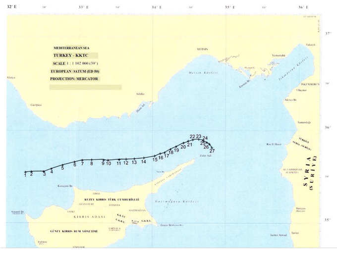
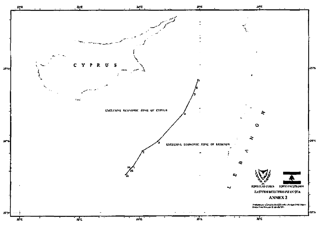
Consider two Egyptian signatures. In 2003 the Greek Cypriot administration and Egypt agreed on an eight-point median line whose endpoints could be reviewed in light of future arrangements with other neighbours. Egypt used the coast of Cyprus in determining that line. In 2004 Ankara notified the UN of the maritime rights generated by its own coast west of 32°16′18″E. And in 2020 Egypt omitted the Meis sector from its agreement with Greece. Where is the corresponding Egyptian signature off Meis? There is none. Athens cannot present Cairo’s agreement with the Greek Cypriot administration as Türkiye’s consent to giving the same effect to another island lying just off its mainland. [126, 2, 127, 153]
On 26 November 2025 the Greek Cypriot administration signed an EEZ boundary agreement with Lebanon. The next day the Turkish foreign ministry expressly stated that the line lay outside the continental shelf Türkiye had notified to the UN. Ankara nevertheless objected. Its objection concerned the failure to respect the Turkish Cypriots’ equal rights and interests and their right to take part in the decisions. Türkiye holds the continental shelf rights generated by the Anatolian coast. The Turkish Cypriot people claim in their own right a say in decisions on the island’s natural resources. The Greek argument that the latter claim merely extends the former cannot explain Ankara’s express acknowledgement that the line lies outside its own shelf. [127, 128, 129]
In March 2026 the Greek Cypriot administration and Egypt announced a new arrangement for developing and marketing gas. The Turkish Cypriot side communicated its objection to the UN in April. Can an allocation of revenue after the terms have been agreed reverse the decisions already taken? It cannot. By then the export route has been chosen, influencing investment costs and negotiating terms with the buyer. The economic value of a procedure safeguarding Turkish Cypriot rights therefore depends on its taking effect before signature. [130, 129, 121]
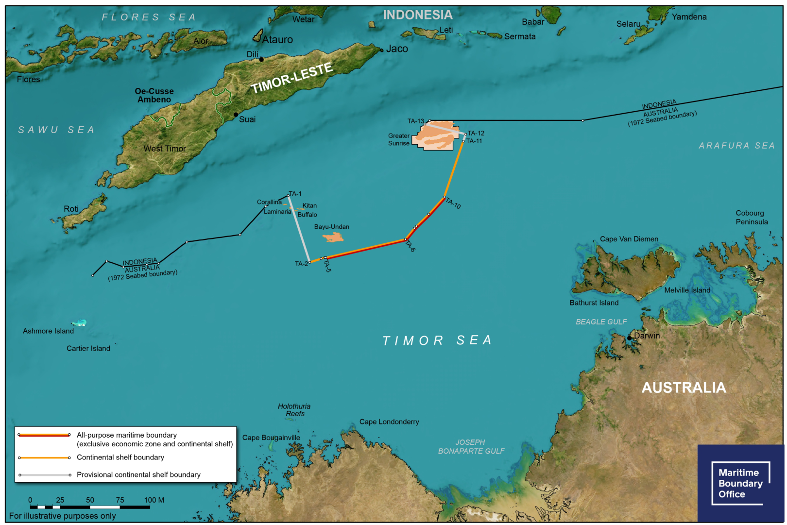
The Timor Sea shows what is at stake. Australia and Timor-Leste disagreed over their boundary for years. Timor-Leste initiated conciliation under the Law of the Sea Convention. With the commission’s assistance the parties settled the boundary in 2018 and established a special regime for the Greater Sunrise gas field. Timor-Leste’s share of upstream government revenue would be 70% or 80%, depending on which country processed the gas. A decision on the direction of a pipeline can thus determine the revenue itself. The promise of future revenue that Athens supports cannot meet the Turkish Cypriots’ demand for a say in setting operating terms today. [131, 132, 133]
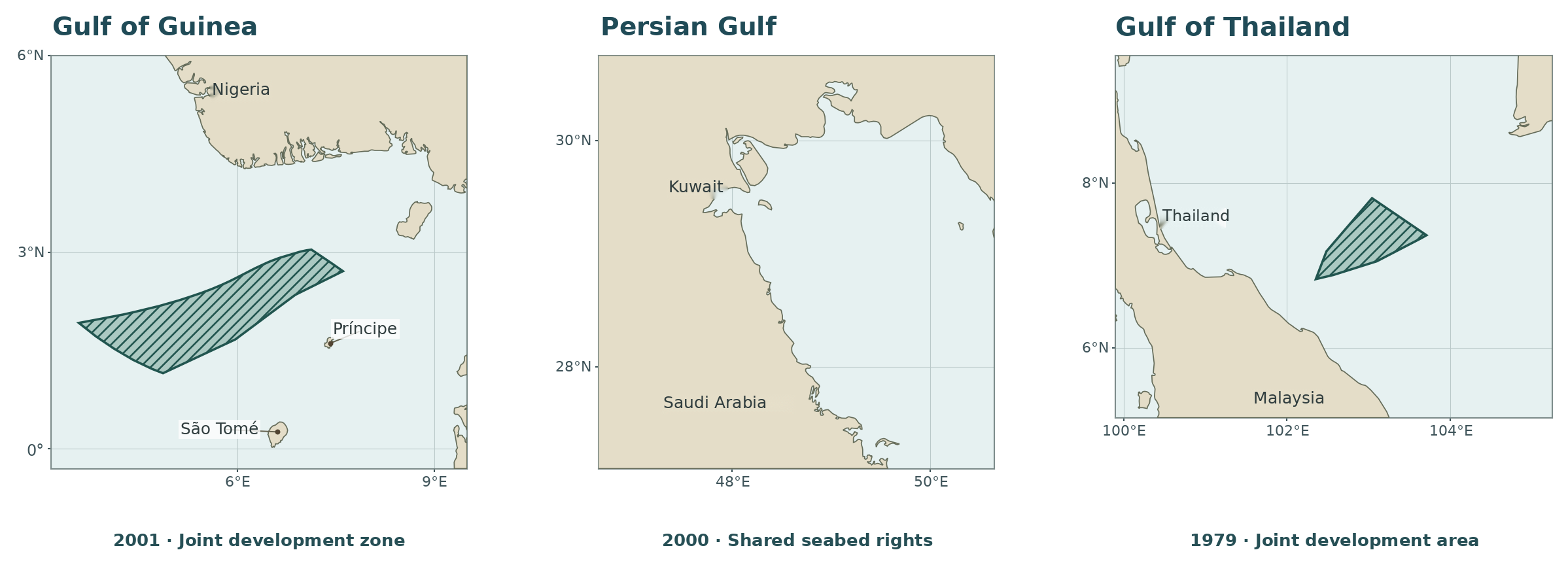
Can parties with competing claims establish a joint decision-making body? Malaysia and Thailand identified the area of overlapping claims and, in a 1979 memorandum, provided for a joint authority over its seabed resources. Nigeria and São Tomé and Príncipe defined their zone in 2001, established a ministerial council and a joint authority, and divided benefits and obligations 60 to 40. The first example shows that joint administration can precede a final boundary. The second shows that equality in decision-making does not require equal revenue shares. The two communities in Cyprus may differ in legal status from the states in these examples. Such a difference bears on how a committee should be constituted. It supplies no grounds for rejecting the committee the Turkish Cypriots have proposed. [134, 135, 136, 137]
Kuwait and Saudi Arabia took the steps in reverse order. They divided the former Neutral Zone in 1965 and separately regulated shared resource rights in the adjacent seabed in 2000. Their joint UN letter of 2026 refers to both instruments. Must all questions of sovereignty be resolved before arrangements can be made for a gas field? Practice shows otherwise. Türkiye seeks to change, on behalf of the Turkish Cypriots, a system that allows one side alone to allocate the island’s future wealth today. The terms of a future political settlement remain open. Athens’ professed commitment to a settlement leaves a question it still has to answer. Who signs while a settlement is pending? Could a single judicial ruling settle all these issues? [138, 139, 11]
How many disputes can one case in The Hague settle?
In September 2026 the Greek foreign minister identified delimitation of the continental shelf and EEZ as the single dispute with Türkiye that could be taken to international adjudication. The states can certainly submit that question to a court. What authority would the judges then have to decide the status of an aircraft eight nautical miles offshore or the procedure for Turkish Cypriot participation in granting a gas licence? A submission limited to the maritime boundary does not itself confer such jurisdiction. The 1954 Monetary Gold case illustrates a further constraint. Albania was not a party to the proceedings, and the requested ruling required a prior decision on its international responsibility. In those circumstances the Court could not proceed. Greece and Türkiye can submit their own dispute. Where Libya’s rights would themselves form the subject matter of the decision, a Greek application cannot stand in for Tripoli. [140, 10, 80, 141]
Greece took the Aegean continental shelf to The Hague in 1976. In November of the same year the two states agreed at Berne on a framework for negotiations. Greece’s foreign ministry now regards that agreement as having lapsed when negotiations broke down in 1981. Ankara maintains that the Berne Agreement remains in force and binding on both parties. The Greek delegation claimed an acquired right to the median line in June 1976. What both parties agreed in November was how to negotiate. Athens did engage in talks. The criticism concerns its attempt to decide from its own map which rights its neighbour can bring to the table. [7, 142, 10, 154]
What boundary did Greece obtain from the 1978 judgment? None. When Greece invoked the 1928 General Act of Geneva, it encountered its own reservation. The Court also found the 1975 Brussels communiqué insufficient to allow a unilateral application. On 19 December it declined jurisdiction without reaching the merits. Greece’s two declarations of 2015 are relevant for the same reason. The first accepted the Court’s compulsory jurisdiction subject to reservations on certain military activities, sovereignty and boundaries. The second excluded the relevant delimitation disputes from compulsory binding procedures under Article 298 of the Law of the Sea Convention. Having defined the limits of its own consent, Athens cannot unilaterally define the scope of Ankara’s consent or the terms of a joint submission. [142, 7, 143, 144]
The joint text adopted in Madrid in July 1997 called for respect for each party’s legitimate, vital interests and concerns in the Aegean. The same text committed both to resolving disputes peacefully, by mutual consent and without the threat of force. When Athens reminds Ankara of the second commitment, what becomes of the first? It remains part of the same political undertaking. The seaward projection of Anatolia, passage regimes and mutual security are legitimate subjects for discussion. Madrid awarded Türkiye no particular coordinate. Nor did it turn an agenda drawn up by Greece alone into an agenda agreed by both. [80, 78, 32]
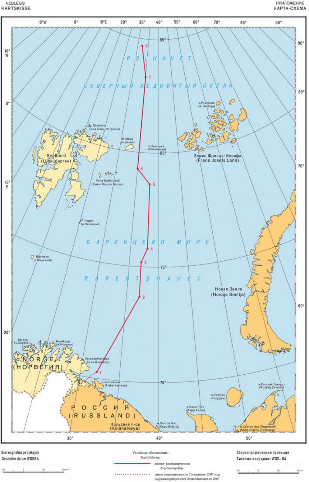
Does negotiating over a median line entail surrendering a right derived from coastal statehood? Norway’s answer in the Barents Sea is a signed agreement. Norway supported a median line, while the Soviet Union and later Russia advocated a different course for the boundary. Between them lay about 175,000 square kilometres. In 2010 the parties agreed on a line dividing the disputed area approximately in half. They maintained fisheries cooperation and established a procedure for deposits straddling the boundary. A NATO member thus negotiated over the median line it advocated while retaining its rights as a coastal state. Athens still owes its neighbour an explanation for treating its own preferred line as the limit of what can be discussed. [145, 146, 140]
Türkiye’s own practice is equally instructive. In 1978 it agreed a continental shelf boundary with the Soviet Union. In 1997 it reached agreement with Bulgaria at the mouth of the Mutludere and at sea. Those agreements, and the Mediterranean memorandum with Libya, would be difficult to explain if Ankara objected to delimitation itself. Its objection concerns the assumption that Athens can decide in advance how much weight the opposite coast will receive. The two states’ 2023 Athens Declaration and February 2026 joint statement already provide a political basis for peaceful talks. At the negotiating table, both parties must be shown how much weight each coast receives and how that affects the coast opposite. [147, 148, 149, 150]
The same standard for Rome and Ankara
The comparison begins and ends with Greece’s own documents. Athens defended the median line against Anatolia as an acquired right in 1976, yet agreed to adjustments when it negotiated with Italy. In its treaty with Egypt it could stop short of Meis. Even its recent UN note describes the line it submitted as provisional pending agreement. What ground, then, remains for treating a Greek map as final solely because Greece published it? None of these documents supplies one. The legal latitude for negotiation that Greece has exercised is equally open to Türkiye as the state on the opposite coast. [1, 2, 7, 9]
Türkiye exercised that right with Libya. The entire A–B segment defined in the 2019 memorandum is the bilateral boundary between the facing coasts of Türkiye and Libya. The coastal base points underlying both endpoints have been published. Identifying a Greek island eliminates neither mainland coast, nor does it give the island full weight in every direction. An entitlement claimed by Greece cannot become a power to set aside the bilateral boundary established by Türkiye and Libya. Ankara can therefore insist on two distinct assessments, one of Kaş and Meis, the other of the south-facing coast of Crete and south-western Anatolia. A map that leaves a blank behind the Greek islands erases a Turkish coast that projects into the open sea in its own right. [3, 12, 4, 43, 44]
The Aegean and Cyprus bring the same difficulty into focus through different instruments. The ten-mile airspace decree cannot identify a corresponding Greek territorial sea beyond six miles. The old chart invoked for Kardak cannot, on its own, establish the authority of those who drew up the December 1932 instrument. In the Paris Treaty, the clause ceding the islands is immediately followed by a military condition that continues to bind Greece. In Cyprus a promise of future revenue gives Turkish Cypriots no voice in setting the terms of a licence today. Which of these issues would a ruling confined to continental shelf and EEZ delimitation decide? None. Each has its own parties, documents and legal answer. [81, 47, 97, 98, 5, 119, 121, 123]
On 26 August 2020 the Greek prime minister could explain to his parliament why some small islands counted for less when he reached agreement with Italy. The more difficult question is why the same calculation cannot be made for the Anatolian coast. If weighing Italy’s coast is described as compromise, while weighing the coast at Kaş is treated as a breach of law, the double standard has both a definition and a documentary record. Türkiye asks that the standard Athens applied in its own case should also apply to the coast opposite. [1, 8, 80]
Documents and sources
Bibliography
- 1. Office of the Greek Prime Minister · Kyriakos Mitsotakis in parliament. 26 August 2020. Reduced island effect on the Italian boundary and the reasons for partial delimitation with Egypt.
- 2. Greece–Egypt EEZ Agreement. UN Treaty Series, I-56237. 6 August 2020, Article 1, coordinates in Annex I and chart in Annex II.
- 3. Türkiye–Libya maritime boundary memorandum and original chart. UN Treaty Series, I-56119. Istanbul, 27 November 2019. Articles I and IV, chart in Annex I and coastal base points in Annex II.
- 4. Türkiye’s letter to the United Nations of 16 February 2026. A/80/642. The Libya boundary, registration, three relevant judgments, the Greek plan and the positions advanced by the Turkish Cypriots.
- 5. Greece · The status of the eastern Aegean islands. Ministry of Foreign Affairs. The different regimes for Lemnos and Samothrace, the four eastern Aegean islands and the Dodecanese.
- 6. Greek Ministry of Foreign Affairs · Cyprus. Greece’s position on the international representation of Cyprus and the political equality of the two communities.
- 7. Greece’s application in the Aegean case. 10 August 1976. Berne talks, paragraph 22 and Annex VI. Median-line claim, paragraph 29(2). Submissions (i) and (ii) following paragraph 32.
- 8. Greece–Italy Continental Shelf Agreement. Athens, 24 May 1977. Article I on the median line and minor adjustments agreed by the parties.
- 9. Greek note verbale to the United Nations. A/79/1005, 3 September 2025. Section D on the map legend and section E on Greece’s demand that measurements be taken from its islands.
- 10. Greece · Delimitation of the continental shelf. 20 June 2024. Island entitlements, the argument that only the Greek island coasts and the Anatolian coast are relevant, and Article 156 of Law 4001/2011.
- 11. United Nations Convention on the Law of the Sea. 1982. Articles 2–3, 15, 17–19, 37–44, 55–58, 74, 76–77, 83, 121–123 and 298.
- 12. Türkiye · Eastern Mediterranean continental shelf notification. UN document A/74/757, 18 March 2020. Grounds and annexed chart, p. 3.
- 13. Grand National Assembly of Türkiye · The area of Blue Homeland. 28th term, second legislative year, 112th sitting. Hulusi Akar’s statement on 462,000 km².
- 14. Grand National Assembly of Türkiye · Eastern Mediterranean symposium. The origin and different uses of the term, including its first use by Cem Gürdeniz in 2006.
- 15. Greece–Italy · Maritime zones. Agreement of 9 June 2020. UN Treaty Series registration and treaty text.
- 16. US Department of State · The Ionian boundary and coastal distances. Limits in the Seas No. 96, 6 June 1982, printed pp. 4–6, particularly points 2, 6 and 8 and the measurement method.
- 17. US Department of State · Greece–Italy boundary chart. Illustrative chart for Limits in the Seas No. 96. Ionian Sea, points 1–16. Florida State University Law Research Center collection.
- 18. Municipality of Megisti · Island geography. Municipality of Megisti/Kastellorizo. Location, settlement and names of the island.
- 19. Greek foreign ministry · Reply to Türkiye’s November letter. November 2019. Greece’s position on areas west of the 28th meridian, competence to conclude agreements with third states and equidistance.
- 20. Türkiye · Objection to the Greek–Egyptian agreement. Ministry of Foreign Affairs, 6 August 2020, No. 165.
- 21. Türkiye’s continental shelf letter to the United Nations. A/68/857, 25 April 2014, annex. The 27 points of the 2011 line and the original ED 50 chart.
- 22. Greece · Response to the Libyan parliament’s decision. Ministry of Foreign Affairs, 20 October 2026. Objections concerning opposite coasts and islands.
- 23. Greece’s reply to the UN of 20 April 2020. A/74/819, pp. 2–3. The coastal projections of Crete and the Dodecanese and the positions of the Turkish and Libyan coasts.
- 24. Greek foreign ministry statement of 28 November 2019. The Greek objection to the Türkiye–Libya memorandum on grounds of third-state rights.
- 25. Turkish foreign ministry statement on Libya of 1 December 2019. Ankara’s reasoning on opposite coasts, island effect and the median line between the mainlands.
- 26. Libya’s letter to the UN of 26 December 2019. A/74/634. Opposite coasts, negotiating history and the powers of the Libyan executive.
- 27. Türkiye’s submission of A–B coordinates to the UN. A/74/727. Letter of 27 February 2020 and the annexed note verbale of 11 December 2019.
- 28. International Court of Justice · Libya/Malta. 3 June 1985, especially paragraphs 64–75. Filfla and the northward shift of eighteen minutes of latitude.
- 29. Malta · Act approving the continental shelf boundary with Libya. Chapter 316. Implementing agreement, Article 1. Eleven points on the European Datum and great-circle arcs.
- 30. Court of Arbitration · United Kingdom/France. 30 June 1977, paragraphs 195–203 and 244–254. The Channel Islands and the Isles of Scilly.
- 31. Vienna Convention on the Law of Treaties. 1969, Article 34. General rule concerning third states.
- 32. Charter of the United Nations. 1945. Articles 2(3)–(4), 33, 51 and 102. Peaceful settlement, threat of force, self-defence and registration.
- 33. Libyan Political Agreement, Skhirat. 17 December 2015, Article 8(2)(f). Powers of the Presidency Council and House of Representatives concerning international agreements.
- 34. Libyan foreign ministry · Unanimous endorsement by parliament. The Libyan government’s account of the House of Representatives’ approval of the maritime memorandum and the rescission of two earlier decisions.
- 35. Libyan Official Gazette, 15 November 2026, No. 15. Year 4. Decisions Nos. 13 and 14 of 22 October 2026 rescinded the 2020 parliamentary decisions rejecting the memorandum and severing political relations.
- 36. Türkiye’s statement on the decision of Libya’s House of Representatives. 20 October 2026, No. 202. Ankara’s view of the decision and the memorandum in force since 2019.
- 37. European Union · Türkiye and Libya. Statement by the High Representative on behalf of the EU, 21 October 2026.
- 38. Egypt · Note verbale to the UN of 5 November 2026. A/81/479. Objections concerning the Libyan parliament’s decision, the 2019 memorandum and hydrocarbon instruments.
- 39. Greece’s objection to the Turkish–Libyan hydrocarbons memorandum. A/77/604. Greek protest concerning implementation of the 2019 boundary instrument through the 2022 cooperation framework.
- 40. Turkish foreign ministry · Hydrocarbons cooperation. 4 October 2022, SC-28. The 2019 boundary and the separate memorandum of 3 October 2022 on cooperation on land and at sea.
- 41. Libya’s note verbale to the UN of 27 May 2025. A/79/916 and annex. The Greek maritime plan and Libya’s objection concerning maritime jurisdiction.
- 42. UN depositary · Convention on the Law of the Sea. Parties, dates of participation and state declarations. Greek ratification, 21 July 1995.
- 43. International Court of Justice · Romania v. Ukraine. 3 February 2009, paragraphs 115–122, 149, 179–188 and 210–216. Sketch-map No. 9 for the final boundary.
- 44. International Tribunal for the Law of the Sea · Bangladesh/Myanmar. 14 March 2012, paragraphs 132–152, 166, 292–297 and 317–319. Sketch-maps Nos. 2 and 9.
- 45. United Nations · Maps accompanying ICJ judgments. ST/LEG/SER.F/1/Add.5. Romania v. Ukraine, sketch-map No. 9, p. 79. Nicaragua v. Colombia, sketch-map No. 11, p. 319.
- 46. Arbitral tribunal · South China Sea. 12 July 2016. Philippines v. China, particularly paragraphs 473–553 and 646. Article 121(3).
- 47. Greece · Islets and sovereignty. Ministry of Foreign Affairs. Lausanne, the 1932 instruments, the 1947 Paris Treaty and the Greek position on Imia/Kardak.
- 48. Italy–Tunisia Continental Shelf Agreement. 20 August 1971, Articles I–II. UN Treaty Series, I-17601.
- 49. US Department of State · Continental Shelf Boundary, Italy–Tunisia. Limits in the Seas No. 89, 1980. Explanation of the agreement and final chart.
- 50. Canada–France arbitral award. Saint-Pierre and Miquelon, 10 June 1992, paragraphs 66–73. Reports of International Arbitral Awards, vol. XXI, pp. 265–341.
- 51. French National Assembly · Maritime boundaries of Saint-Pierre and Miquelon. Information report No. 1312, Annick Girardin and Louis Guédon. The parties’ claims and the outcome of the 1992 arbitration.
- 52. International Court of Justice · Nicaragua v. Colombia. 19 November 2012, paragraphs 126–131, 229–238 and following. Sketch-map No. 11 for the final boundary.
- 53. International Court of Justice · Greenland and Jan Mayen. Denmark v. Norway, 14 June 1993, paragraphs 61–80. Coast lengths and access to fisheries.
- 54. United Nations · ICJ decisions and official sketch-maps, 1992–1996. ST/LEG/SER.F/1/Add.1. Summary of the 1993 Denmark v. Norway judgment and sketch-map No. 2.
- 55. International Court of Justice · North Sea Continental Shelf cases. Federal Republic of Germany/Denmark and Federal Republic of Germany/Netherlands, 20 February 1969, paragraphs 85, 91 and 101.
- 56. Natural Earth coastline data · World Atlas. Version 2.0.2, base map at 1:10 million. The North Sea and Channel panels use land-10m.json.
- 57. United Nations · ICJ decisions and official sketch-maps, 1948–1991. ST/LEG/SER.F/1. Summaries of the North Sea, Tunisia/Libya, Gulf of Maine and Libya/Malta cases, with the Maine and Kerkennah sketch-maps.
- 58. International Court of Justice · Tunisia/Libya. 24 February 1982, paragraphs 128–129. The Kerkennah Islands and half effect.
- 59. Chamber of the International Court of Justice · Gulf of Maine. Canada/United States, 12 October 1984, paragraph 222. The effect of Seal Island on delimitation.
- 60. Greek Government Gazette · National maritime spatial strategy. Gazette D’ 229, 17 April 2025, pp. 2210–2211. Four planning units and map legend.
- 61. Greece · Proposed Turkish maritime legislation. 14 May 2026. George Gerapetritis on unilateral legislation and bilateral or multilateral arrangements.
- 62. European Union · Maritime Spatial Planning Directive. Directive 2014/89/EU, particularly Article 2(4). The effect of planning on maritime boundaries.
- 63. Türkiye · Maritime spatial plan. DEHUKAM national platform. Plan legend, mainland median line and explanatory notes on the Black Sea and the EEZ.
- 64. Turkish foreign minister · The Seville map. Interview of 16 September 2020. Türkiye’s interpretation of the status of the map.
- 65. DEHUKAM · Draft law on maritime jurisdiction. Ankara University press conference, 12 May 2026. Planning map and draft legislation.
- 66. International Court of Justice · Somalia v. Kenya. Judgment of 12 October 2021. The alleged tacit boundary and the evidence required to establish a boundary along a parallel of latitude.
- 67. Greece · Objection to Turkish marine parks. Ministry of Foreign Affairs, 16 August 2026. The decrees of 15 August and the Greek objection.
- 68. Greek Ministry of Environment and Energy. 2025. Public consultation on marine parks in the southern Cyclades and the Ionian Sea.
- 69. Türkiye · Fethiye–Kaş Marine National Park. Ministry of Agriculture and Forestry, Sixth Regional Directorate. Official account of the conservation objective.
- 70. International Maritime Organization · NAVTEX Manual. MSC.1/Circ.1403/Rev.2, paragraph 1.1.
- 71. Guyana/Suriname maritime arbitration. 17 September 2007, especially paragraphs 459–461. Duties to seek provisional arrangements and avoid jeopardising a final agreement.
- 72. Greece · The territorial sea and the 1995 declaration. Ministry of Foreign Affairs. Official position on the twelve-mile entitlement and the threat of force.
- 73. European Environment Agency · Greece’s maritime areas. Greek national assessment. Law 4767/2021 and the twelve-mile territorial sea in the Ionian.
- 74. Türkiye · Outstanding Aegean issues. Ministry of Foreign Affairs. The continental shelf, territorial sea, sovereignty, island status and airspace.
- 75. International Hydrographic Organization. Definition of the international nautical mile. One nautical mile equals 1,852 metres.
- 76. Greek Ministry of Foreign Affairs · Maritime boundaries. The separate legal grounds invoked for the Evros/Meriç, the area around Samos and the waters off the Dodecanese.
- 77. Türkiye · Six- and twelve-mile maps of the Aegean. Ministry of Foreign Affairs, Ç. Erciyes, 13 February 2020, slide 10. Percentages under the two scenarios.
- 78. Grand National Assembly of Türkiye · Declaration of 8 June 1995. The proceedings of 13 June 1995 reproduce the declaration of the 121st sitting.
- 79. International Court of Justice · Corfu Channel. Judgment on the merits, 9 April 1949. Innocent passage in peacetime through the North Corfu Channel.
- 80. Madrid · Joint undertakings by Greece and Türkiye. 8 July 1997. Joint text released by the US Department of State on legitimate and vital interests in the Aegean and the avoidance of threats of force.
- 81. Greece · National airspace. Ministry of Foreign Affairs. The ten-mile claim based on the 1931 decree and subsequent practice.
- 82. Greek aviation decree of 1931. 6/18 September 1931. Original instrument defining the breadth of territorial waters for aviation purposes. UN Division for Ocean Affairs and the Law of the Sea.
- 83. Chicago Convention. 1944. Convention on International Civil Aviation, Articles 1–3. International Civil Aviation Organization.
- 84. US Department of State · Maritime claims and boundary disputes. Limits in the Seas No. 36, eighth revision, Greece, p. 63. Record of the 1994 protest.
- 85. International Court of Justice · Temple of Preah Vihear. Cambodia v. Thailand, 15 June 1962, especially pp. 22–33. Receipt of the boundary map and subsequent conduct.
- 86. Greece · Athens Flight Information Region. Ministry of Foreign Affairs. Official position on flight safety and FIR responsibility.
- 87. Greek Ministry of Foreign Affairs · Search and rescue. Aeronautical and maritime search and rescue regions, the Athens FIR and the Greek case for coordination.
- 88. International Maritime Organization · Legal Affairs. LEG/MISC.8. Annex to the Search and Rescue Convention, paragraph 2.1.7 on state boundaries.
- 89. International Maritime Organization · Status of IMO Treaties. Greek and Turkish declarations on search and rescue regions.
- 90. Turkish Ministry of Foreign Affairs · Kardak and the 1932 instruments. The Turkish position on the legal effects and registration of the January convention and December instrument.
- 91. Treaty of Peace with Türkiye, Lausanne. 24 July 1923, especially Articles 12, 13 and 15. Turkish foreign ministry archive.
- 92. Treaty of Peace with Italy, Paris. 10 February 1947, Article 14. The Dodecanese and the demilitarisation provision. UN Treaty Series, vol. 49.
- 93. Türkiye–Italy Convention of 4 January 1932. League of Nations Treaty Series, vol. 138, No. 3191, pp. 243–249. Scope and provisions on the transfer of title.
- 94. Leonidas Kallivretakis · The Limnia–Imia document. National Hellenic Research Foundation, 1996. Historical study of plates 5 and 6 and of Turkish and Greek maps.
- 95. International Court of Justice · Qatar v. Bahrain. 1 July 1994, especially paragraphs 23–30. Legal character and binding provisions of the 1990 Doha minutes.
- 96. International Court of Justice · Burkina Faso/Mali. Frontier Dispute, 22 December 1986, paragraphs 54–56. Maps as legal instruments or supporting evidence.
- 97. Greece’s UN letter on the status of the islands. 25 May 2022, A/76/846. Three treaty regimes, self-defence, sovereignty and the objection based on Libya v. Chad.
- 98. Türkiye’s UN letter on the eastern Aegean islands. 13 July 2021, A/75/961. The conditions of cession, military restrictions and Türkiye’s objection to Greece invoking sovereign title against it in maritime delimitation.
- 99. Turkish foreign ministry · Military status of the eastern Aegean islands. Lausanne and Montreux, the three groups of islands and Türkiye’s position on the Paris Treaty.
- 100. Finland’s mission to NATO · The status of Åland. Finland’s statement on demilitarisation and neutralisation following accession to NATO.
- 101. Finnish foreign ministry · Technical document on the Åland zone. Original chart on the final page, Annex 5. Separate lines for the special zone, territorial sea and economic zone.
- 102. Convention on the Non-Fortification and Neutralisation of the Åland Islands. Geneva, 20 October 1921. League of Nations Treaty Series, No. 255.
- 103. International Court of Justice · Libya/Chad land boundary. UN summary of the judgment of 3 February 1994. Permanence of a boundary established by treaty.
- 104. Greek foreign ministry · Cyprus since 1960. Athens’ account of the 1960 partnership, the 1963 dispute and the events of 15 and 20 July 1974.
- 105. Turkish foreign ministry · Historical account and position on Cyprus. The 1960 partnership, the events of 1963, the Greek junta’s coup and Ankara’s grounds for action.
- 106. Treaty of Guarantee concerning Cyprus. Nicosia, 16 August 1960, UN Treaty Series, vol. 382, p. 3. Particularly Articles I, II and IV.
- 107. United Nations Peacekeeping Force in Cyprus · Establishment and mandate. The 1963–64 crisis, the establishment of the force in March 1964 and subsequent developments.
- 108. Makarios’s Security Council address of 19 July 1974. S/PV.1780. His testimony on the coup and the Greek military regime.
- 109. UN Security Council Resolution 353. 20 July 1974. Ceasefire, intervention and military personnel present without the authority of international agreements.
- 110. UN Secretary-General’s report on the Cyprus referendums. 28 May 2004, S/2004/437. Results of the separate votes and the settlement process.
- 111. Greek Cypriot administration · Assessment of the Annan Plan. Foreign ministry account of the Greek Cypriot side’s objections concerning security, guarantees, property and implementation.
- 112. EU Act of Accession · Protocol No. 10 on Cyprus. Article 1. Suspension of the acquis in areas outside the effective control of the Greek Cypriot administration.
- 113. UN Security Council Resolution 541. 18 November 1983. The declaration of independence and the call for non-recognition, especially paragraphs 2 and 7.
- 114. UN Security Council Resolution 550. 11 May 1984. Secession and calls for non-recognition and non-assistance.
- 115. TRNC foreign ministry · Statement on the Cyprus issue. 21 September 2026. The government’s stated demand for sovereign equality and equal international status.
- 116. UN Cyprus talks · Statement of 9 November 2026. The two leaders’ discussion of confidence-building measures, procedure and substance.
- 117. European Court of Human Rights · Loizidou v. Turkey, merits. 18 December 1996, application No. 15318/89. Access to property and responsibility based on effective control.
- 118. European Court of Human Rights · Demopoulos and Others v. Turkey. Grand Chamber, 1 March 2010. Admissibility and the effectiveness of the Immovable Property Commission remedy.
- 119. Greek Prime Minister Antonis Samaras · Energy rights in Cyprus. Greek foreign ministry archive. Support for the right of the Greek Cypriot administration to exploit hydrocarbons.
- 120. Greek Cypriot administration · Energy and maritime policy. Foreign ministry account of the EEZ, agreements with coastal neighbours and licensing.
- 121. UN Secretary-General · Report on Cyprus. S/2013/392, 5 July 2013, paragraph 43. Both communities as beneficiaries of natural resources.
- 122. Turkish Cypriot and Greek Cypriot leaders · Joint declaration of 11 February 2014. UN Good Offices Mission in Cyprus. The envisaged federation, political equality and a single international legal personality.
- 123. Turkish Ministry of Foreign Affairs. 13 July 2019. The Turkish Cypriot proposal for joint management of hydrocarbon resources and revenue sharing.
- 124. Nicos Anastasiades · Address to the UN General Assembly. 26 September 2019. Proposed escrow account for the Turkish Cypriot share of revenue. Greek Cypriot representation at the UN.
- 125. Turkish Ministry of Foreign Affairs. 21 September 2011. Continental shelf agreement between Türkiye and the TRNC.
- 126. Greek Cypriot administration–Egypt EEZ agreement. 17 February 2003, I-44649, Articles 1 and 3, Annex I. The eight points and conditions for revisiting the endpoints.
- 127. Greek Cypriot administration–Lebanon agreement and original chart. 26 November 2025, I-59144. English text, Annex I (coordinates) and Annex II (illustrative chart), PDF pp. 6–9.
- 128. Türkiye · Response to the agreement between Lebanon and the Greek Cypriot administration. Foreign ministry spokesperson, 27 November 2025. The segment outside Türkiye’s notified shelf.
- 129. Turkish Cypriot representative · Letter to the United Nations. A/80/721–S/2026/367, 22/24 April 2026. Objection to the 30 March framework agreement with Egypt.
- 130. Greek Cypriot leader Nikos Christodoulides. 30 March 2026. Remarks in Cairo on energy cooperation with Egypt.
- 131. Australia–Timor-Leste · The Timor Sea. Australian Department of Foreign Affairs and Trade. The 2018 boundary treaty, conciliation and the Greater Sunrise Special Regime.
- 132. Timor-Leste Land and Maritime Boundary Office · Map 6. Official chart of the maritime boundary agreement with Australia.
- 133. Permanent Court of Arbitration Registry · Timor Sea Conciliation. Australia and Timor-Leste. Commission report, agreement and procedural documents, case No. 2016-10.
- 134. Malaysia and Thailand · Memorandum on a joint authority. 21 February 1979, particularly Articles III–IV. Non-living resources of the designated seabed and joint benefit.
- 135. Malaysia–Thailand Joint Authority. Implementation of the 1979 memorandum and 1990 agreement. Mandate and area of responsibility.
- 136. Nigeria–São Tomé and Príncipe Treaty of 2001. 21 February 2001. The joint zone, allocation of benefits and obligations, and joint institutions.
- 137. Gulf of Guinea · Coordinates of the joint zone. 2019 EU–São Tomé and Príncipe fisheries protocol, Appendix 1. The coordinates were compared with the 32 entries in Article 2 of the 2001 treaty.
- 138. Kuwait–Saudi Arabia · Agreement on the adjacent submerged area. 2 July 2000. Boundary and natural resource rights in the submerged area adjacent to the partitioned zone.
- 139. Kuwait and Saudi Arabia · Joint letter to the UN. 15 June 2026, A/80/779–S/2026/499. Explanation of the 1965 and 2000 arrangements.
- 140. Greece · The dispute that may be submitted to adjudication. Foreign Minister George Gerapetritis, 12 September 2026.
- 141. International Court of Justice · Monetary Gold Removed from Rome in 1943. 15 June 1954. Albania was not a party, yet its responsibility would have been the very subject matter of the decision. UN summaries of judgments, case No. 21.
- 142. International Court of Justice · Aegean Sea Continental Shelf. 19 December 1978. Greece v. Turkey, judgment on jurisdiction in case No. 62.
- 143. UN depositary · Greek declaration on ICJ jurisdiction. 14 January 2015. Reservations to the unilateral declaration accepting compulsory jurisdiction.
- 144. UN depositary · Greek declaration under Article 298 of the Law of the Sea Convention. 16 January 2015, C.N.32.2015.TREATIES-XXI.6. Scope of compulsory procedures in maritime delimitation.
- 145. Government of Norway · The Barents Sea boundary. The maritime boundary and nearly forty years of negotiations.
- 146. Norway–Russia Treaty on Maritime Delimitation and Cooperation in the Barents Sea and the Arctic Ocean. 15 September 2010. Articles 1 and 4–5, annexes on cooperation and overview map.
- 147. Türkiye–USSR · Black Sea continental shelf. Moscow, 23 June 1978. Article 1 and boundary coordinates.
- 148. Türkiye–Bulgaria · Mutludere and the Black Sea. Sofia, 4 December 1997, I-36204. Delimitation at the river mouth and in the Black Sea.
- 149. Greece and Türkiye · Athens Declaration. 7 December 2023. Good-neighbourly relations, peaceful dispute settlement and preservation of the parties’ legal positions.
- 150. Greece and Türkiye · Ankara joint statement. 11 February 2026. Good-neighbourly relations, consultation and cooperation.
- 151. Grand National Assembly of Türkiye · Foreign minister’s written answer on Kardak. The Turkish government’s position on sovereignty over the Kardak rocks.
- 152. Turkish Ministry of Foreign Affairs · Hakan Fidan’s interview with Anadolu Agency. 8 August 2026. Türkiye’s position on a two-state settlement in Cyprus.
- 153. Turkish Ministry of Foreign Affairs · Maritime jurisdiction in the Eastern Mediterranean. 9 August 2007. The UN note of 2 March 2004 and Turkish rights west of 32°16′18″E.
- 154. Turkish Ministry of Foreign Affairs · The delimitation of the Aegean continental shelf. Ankara’s position that the Berne Agreement remains in force and binds both parties.