Knowledge / Navigation and marine safety
Current set and drift: estimating water motion from inconsistent measurements
Estimate current by subtracting aligned velocity vectors, then test heading bias, sensor delay, leeway and uncertainty.
On this page
A current estimate is often the difference between two much larger measured motions. That makes it sensitive to small mismatches in direction, timing and sensor meaning. The arithmetic becomes useful when those assumptions are made explicit.
An estimated current is a residual
For a horizontal reference point, ground velocity equals water-relative velocity plus the local water velocity: vG = vW + c. Therefore c = vG − vW. The subtraction is simple only after both velocities describe the same time, place, reference point and axes. A current estimate obtained from inconsistent inputs can absorb every inconsistency and still look like a believable arrow.
Current set is the direction toward which the water moves, while drift is its speed. A wind direction convention often describes where wind comes from, so importing that convention into a current label reverses the result. The examples use true-north bearings clockwise and east/north components. They estimate a kinematic residual; identifying it as actual current requires evidence that the vessel’s water-relative motion is adequately measured.
Distinguish a speed magnitude from a velocity vector
A single-axis speed log does not automatically measure the complete horizontal water-relative velocity. Heading plus longitudinal speed assumes that unmeasured transverse motion is negligible or separately handled. IMO MSC.96(72), annex on speed and distance measuring devices, adopted 22 May 2000, distinguishes measurement modes and recognizes environmental influences to be described in the equipment handbook. The applicable model and approval must be checked rather than assuming every log has the same output.
Wind-induced leeway, hull sideslip in a turn, sensor alignment and the depth sampled by a Doppler log can all matter. GNSS course over ground describes ground translation, not hull heading. Subtracting SOG minus STW as two scalar numbers discards direction and cannot recover a general current vector. Equal SOG and STW do not prove that current is zero.
A component example exposes the scalar trap
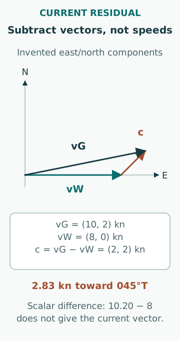
Assume synchronized observations yield ground velocity vG = (10.00, 2.00) kn, and a reliable full water-relative estimate is vW = (8.00, 0.00) kn. The current residual is c = (2.00, 2.00) kn: 2.83 kn toward 045.00°T. Ground speed is sqrt(10² + 2²) = 10.20 kn, on 078.69°T. Subtracting 8.00 from the rounded 10.20 gives 2.20 kn, which is neither the correct current magnitude nor its direction.
The result is an original idealized example with uniform current and no acceleration. Over fifteen minutes, the inferred water displacement relative to ground is (0.50, 0.50) NM, magnitude 0.707 NM. That displacement is not the vessel’s cross-track error unless the planned track and compensating vessel motion are also specified. A current arrow describes the water motion, not an automatic navigation correction.
Heading bias can masquerade as cross-current
Suppose the water-speed magnitude is 8.00 kn and the actual direction is due east, but the heading used to construct the vector is 093°T. The constructed north component becomes 8 cos 93° = −0.419 kn. Subtracting that from a correct ground velocity introduces an apparent northward current increment of 0.419 kn. A modest angular bias has produced a substantial residual without any change in the water.
Conversely, genuine leeway can make the heading-based water vector wrong even when the compass is accurate. The observed mismatch cannot by itself identify which mechanism applies. Useful checks examine heading calibration, log mode, vessel manoeuvring state and independent current information. Adjusting a current estimate until the plot looks smooth may merely conceal an instrument or modelling error.
Match averaging windows and timestamps
A GNSS velocity averaged over one interval and a log value filtered over another need not describe the same motion during acceleration. A displayed “current” jump at a turn can be the difference between differently delayed measurements. Timestamping receipt of a message does not establish when the underlying measurement was made.
For an original sensitivity example, suppose the east component of vessel water velocity changes at 0.04 kn/s for a short interval. Pairing a present ground velocity with a water velocity ten seconds old can create a 0.40 kn eastward residual error, before other effects are included. The constant-rate assumption is illustrative. Correcting a known fixed delay is different from claiming that a variable or unknown delay has disappeared.
Uncertainty grows when two similar vectors are subtracted
If two large velocity estimates are nearly equal, their small difference can have a large relative uncertainty. Assume independent east-component standard uncertainties of 0.15 kn for ground velocity and 0.20 kn for water velocity. The current east-component standard uncertainty is sqrt(0.15² + 0.20²) = 0.25 kn. A nominal 0.10 kn residual is then poorly resolved relative to that uncertainty.
The uncertainty in set becomes particularly unstable near zero drift: a tiny component change can rotate the inferred direction sharply. Reporting a current set to a tenth of a degree in that condition is misleading precision. Correlations, systematic offsets and unmeasured transverse velocity are not removed by averaging repeated samples. Describe them separately from random measurement scatter.
Compare like with like in external current information
NOAA CO-OPS product descriptions distinguishes observed currents, tidal-current predictions and numerical nowcast/forecast guidance. Its API also identifies a measurement bin for suitable current products. A subsurface current at one station is not automatically the surface current at the ship, and a tidal prediction need not include every non-tidal contribution.
When comparing, record depth, location, time, direction convention and whether the value is an observation or model output. A difference can be physically real because of shear or spatial variation. A model agreement can also be coincidental if both estimates have large uncertainty. External information is most useful as another evidence path whose own scope is understood.
A second steady run can test a bias hypothesis
In an educational dataset, compare steady intervals on two different headings while assuming the local current remains unchanged. A residual error that rotates with the vessel is consistent with a body-axis measurement problem, whereas a stable earth-fixed residual is more consistent with a current component. This is a diagnostic hypothesis, not proof: the current may vary between the intervals.
Record the elapsed time, positions, loading state and sensor modes for both runs. Discarding those conditions can make an environmental change look like calibration error. Such comparison uses already available observations or authorized trials; it does not justify changing course in a real traffic situation merely to improve an estimate.
Diagnose the residual before using it
A useful evaluation retains the component time series rather than only set and drift. Plot ground east/north, water east/north and their differences on the same time base. Mark turns, log-mode changes, lost inputs and source substitutions. Examine whether the residual changes with vessel heading, acceleration or sensor selection. Those patterns can distinguish a persistent environmental signal from a vessel-dependent error.
Common mistakes are scalar subtraction, using heading as water-track direction without a leeway assumption, forgetting current depth, averaging across turns and calling the whole residual “tide.” An estimate should carry its time window, source chain, uncertainty and unresolved biases. It is evidence for navigation assessment, not a substitute for the full passage plan or a guaranteed correction to apply.
Sources
- MSC.96(72): Amendments to performance standards for devices to indicate speed and distance · IMO · Source check date: 2026-10-06
- CO-OPS Products · NOAA CO-OPS · Source check date: 2026-10-06