Knowledge / Navigation and marine safety
Virtual AIS aids to navigation: distinguishing a displayed mark from a physical buoy
Read physical presence, transmitter location, position and status separately, using an original AIS AtoN classification and offset example.
On this page
An electronic aid can mark a useful position without placing a buoy there. The central question is what the report represents: a physical aid, a remotely reported physical aid, or an entirely virtual mark. Separating that meaning from reception quality prevents a convincing symbol from becoming unsupported evidence about the water outside.
Start with the object represented
An AIS aid-to-navigation report belongs to a different object class from a ship position report. Its name and plotted position describe an aid or designated mark. They do not turn that mark into a moving vessel. The Canadian Coast Guard’s Message 21 description separates identity, aid type, position and status fields; each answers a different question.
A useful reading sequence is therefore semantic before geometric: identify the reported object, establish whether a physical aid is expected, and only then assess the position and status evidence. A calculated distance from a symbol may be perfectly accurate while the interpretation of the symbol is wrong. More decimal places cannot repair that category error.
Separate physical, synthetic and virtual
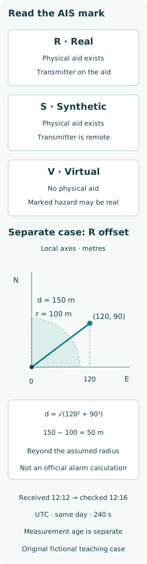
A physical or real AIS AtoN has the transmitting equipment on the physical aid. A synthetic report is transmitted elsewhere but refers to a physical aid; a virtual report represents an aid that is absent physically. The Coast Guard distinguishes monitored synthetic reports from predicted synthetic reports: the latter lack confirmation of the physical aid’s position and status.
Thus “transmitted from shore” does not settle physical presence. Both a synthetic aid and a virtual mark can have a remote transmitter. Similarly, knowing that a buoy exists does not establish that its light is working or that it remains at its assigned position. Presence, location and condition are separate propositions, with separate evidence requirements.
Read the flag without overreading it
The US Coast Guard’s Message 21 reference identifies the virtual flag and qualifies use of the floating-aid off-position indicator. It also distinguishes a valid UTC-second field from special values indicating unavailable or degraded positioning information. The UTC-second field alone is not a complete date-and-time record; receipt history and receiver presentation still matter.
The practical inference is narrower than “all green means safe.” A field describes the supplied report under its encoding rules. An omitted, default or unavailable field cannot establish the corresponding physical condition. Nor does a virtual mark’s lack of a buoy establish that its surroundings are obstacle-free: the mark may be communicating the existence of a hazard.
Build a fictional three-mark comparison
Consider a classroom display with marks R, S and V. R has an AIS unit on a buoy. S is a monitored synthetic report about another buoy, transmitted by a shore station. V is a virtual mark assigned to a hazard boundary, also transmitted from shore. R and S imply expected physical aids; V does not. These letters are teaching labels, not real identifiers.
Suppose R and S are not visible from the classroom vessel’s assumed position. That observation alone does not convert either into a virtual mark. Visibility, range and obstruction are still possible explanations. Conversely, failing to see a buoy at V is consistent with its meaning. The classification changes the expected observation before any discrepancy is investigated.
Calculate an offset on declared axes
For R alone, define a local east–north plane in metres. Its assigned position is (0, 0), and a fictional reported position is (120, 90). The radial offset is d = √(120² + 90²) = 150 m. This uses a small local Cartesian diagram, not latitude–longitude subtraction or a chart projection suitable for an actual voyage.
Introduce a hypothetical circular radius of 100 m solely to illustrate the comparison. The reported point lies 50 m beyond it. This does not compute safe passing distance, prove a mooring failure or reproduce the provider’s alarm. The original figure deliberately keeps that arithmetic separate from the three physical-presence classes, so a distance result cannot decide whether an aid exists.
Distinguish an offset from an off-position decision
IALA R0126 treats position monitoring as a configured service, including the relationship between a floating aid and its assigned position. A provider’s guard region, sensing and reporting logic are part of that service. The circle in this article is an explanatory assumption; no actual aid’s threshold is supplied or inferred.
Even within the toy case, a measured point and its uncertainty must be distinguished. A small apparent displacement could reflect measurement error or normal motion; a larger one needs investigation rather than automatic diagnosis. Comparing 150 m with 100 m is valid arithmetic, but labeling the cause requires information that those two numbers do not contain.
Separate report receipt from observation freshness
Assume the latest message was received at 12:12 UTC and the classroom assessment occurs at 12:16 UTC on the same day. Receipt age is 240 s. That calculation establishes elapsed time since reception only. It does not establish when a remote station last measured a buoy or whether the receiver is retaining an older report behind a recent display refresh.
Write the time basis beside any age: observation, transmission, receipt or screen update. In this case, measurement age remains unknown unless further data provide it. A predicted synthetic report particularly illustrates why a regular radio update cannot itself confirm an unmonitored physical condition. This is an evidence-chain issue, not a reason to assign a universal timeout to every aid.
Make cross-checks test different propositions
A visual observation can support the presence of a buoy; a radar return can support an object at a bearing and range; an official aid description can explain intended characteristics. Agreement between two screens fed by the same AIS stream mainly confirms presentation consistency. It is not two independent observations of the buoy’s physical position.
For the classroom marks, list the disputed proposition explicitly. For R it might be “at the assigned position”; for S, “remote monitoring is current”; for V, “the designated mark remains applicable.” This keeps the investigation from chasing a nonexistent buoy at V or treating shore-station coordinates as the location of S. The tests should match the claim being tested.
Treat symbols as an interface to information
The equipment’s approved symbology and object query explain how an AIS AtoN is presented. A familiar outline in a screenshot is insufficient evidence for all receiver types, display settings or software versions. The teaching figure uses labeled cards and simple geometry, rather than pretending to reproduce a certified radar or electronic-chart display.
Inspecting the object details should resolve more than a name: the classification, identity, reported position and relevant status must agree as an interpretation. If details are absent or contradictory, preserve that uncertainty in the assessment. Inventing missing status from the color of an icon converts a presentation convention into a physical measurement that was never made.
Carry the meaning into the assessment
The completed classroom record has three independent outputs: R and S have expected physical aids while V does not; R’s assumed displacement is 150 m; and its receipt age is 240 s. None subsumes the others. The record also states what remains unestablished, including actual measurement age, applicable provider threshold and physical cause of displacement.
A useful operational assessment would need the authorized service information, current chart and warnings, equipment instructions and shipboard procedures relevant to the actual situation. The original exercise supplies no live aid status or route clearance. Its transferable result is the discipline of keeping physical presence, transmitter location, report geometry and observation freshness distinct until evidence connects them.