Knowledge / Navigation and marine safety
Celestial positioning: sextant altitude, timing error and position-line geometry
Follow a fictional sextant sight through corrections, an altitude intercept and two intersecting position lines; separate timing bias from geometry and ship motion.
On this page
A celestial sight is an angular observation tied to a body, a horizon and a time. It becomes a position constraint only after those meanings survive the correction and reduction process. An original two-line example shows why a neat intersection can still be weak evidence when timing, common bias or crossing geometry is poorly controlled.
Record the observation before reducing it
A usable sight record identifies the body, observed limb or center, sextant altitude, time standard, instrument correction and height of eye. Horizon quality and observation conditions matter because they affect what angle was actually measured. USNO lists the Nautical Almanac and official sight-reduction resources for connecting such observations to astronomical positions.
Celestial observation can add a different measurement family to a position check, but its independence is conditional. If its time or assumed position is copied from a suspect electronic source without examination, some shared dependence remains. The observed altitude is new evidence; the full processing chain is not automatically independent merely because a sextant was involved.
Keep sextant, apparent and observed altitude distinct
USNO’s reduction notes distinguish instrument and dip adjustment from the subsequent refraction, semidiameter and parallax corrections. Corrections must match the body, limb and conditions; a lower-limb solar correction cannot simply be reused for a star. The service also specifies its atmospheric and time assumptions, which belong beside the output rather than being silently ignored.
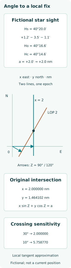
For an original fictional star sight, take Hs = 40°20.0′, a signed index correction of +1.2′, dip correction −3.5′ and refraction correction −1.1′. Semidiameter and parallax are zero at the chosen precision. Then Ho = 40°16.6′. These supplied corrections demonstrate bookkeeping; they are not calculated from a real height of eye, atmospheric report or observation date.
Obtain the computed altitude on the same basis
For assumed latitude φ, body declination δ and local hour angle H, sin Hc = sin φ sin δ + cos φ cos δ cos H. USNO gives this spherical altitude relation and warns to keep angular units consistent. A program using radians must convert degree inputs before calling trigonometric functions; the output convention must be equally explicit.
The classroom reduction supplies Hc = 40°14.6′ and true azimuth Z = 90° for the same hypothetical sight. It does not claim these values describe a named star on a real date. Keeping that boundary explicit lets the exercise isolate the intercept operation without fabricating an almanac entry or suggesting the numbers can determine a vessel’s present position.
Turn the altitude difference into a local line
The intercept is a = Ho − Hc = +2.0′. Under the conventional spherical nautical-mile approximation, that is 2.0 nautical miles toward the body’s geographical position. A negative intercept would be plotted away. The local position line is perpendicular to the azimuth, through the displaced intercept point; it is not a ray pointing at the celestial body.
Write x east and y north in nautical miles. To first order near the assumed position, x sin Z + y cos Z = a. For Z = 90°, this becomes x = 2.0. The equation describes a line of possible positions; it does not determine y. Treating the intercept point itself as the fix discards that remaining degree of freedom.
Intersect two lines with an explicit convention
Supply a second, already reduced fictional intercept of +1.0 nautical mile at Z = 120°, referred to the same epoch. Its equation is 0.866025x − 0.5y = 1.0, using the rounded sine coefficient for display. Solving with x = 2.0 gives y = 1.464102 nautical miles when the full trigonometric value is retained.
The result is an east–north offset from the assumed position, not an absolute latitude and longitude. The native diagram labels both azimuth normals and the distinct position lines. Its modest local scale supports the tangent approximation. A large intercept, high precision requirement or complex observation sequence calls for a reduction appropriate to that geometry rather than stretching this sketch indefinitely.
Quantify what a shallow crossing does
Hold the first line fixed and perturb the second intercept by Δa. For crossing angle θ, the displacement along the first line has magnitude |Δa|/|sin θ|. At 30° the amplification is 2.000000; at 10° it is 5.758770. This is a directional sensitivity, not a universal circular error radius or a probability of being within a plotted triangle.
With independent intercept standard deviations of 0.5 nautical mile in both lines of the example, σy = √[(cos 30° × 0.5)² + 0.5²]/sin 30° = 1.322876 nautical miles. At an orthogonal crossing the corresponding value would be 0.5. The uncertainty is elongated; a tidy point on paper conceals that direction-dependent weakness unless the geometry is reported.
Translate time error through the body geometry
For a simple clock illustration, use an approximate rotation rate of 15 arcseconds per second. A 4 s timing offset then corresponds to about 1.0′ of hour angle. At latitude 60°, a 1.0′ longitude displacement spans about 0.5 nautical mile along the parallel. This scale comparison is not a claim that every sight acquires that much position-line error.
Altitude responds through the spherical equation: ∂Hc/∂H = −cos φ cos δ sin H / cos Hc, with compatible angular units. The response varies with body geometry, and astronomical hour-angle rates are not identical for every body. A shared clock error can shift several reductions coherently; taking more sights with the same biased clock need not average that bias away.
Refer observations to a common epoch
USNO’s celestial-navigation algorithms explicitly incorporate a moving observer. That matters when sights are sequential. A line from an earlier time and a line from a later time constrain different vessel positions unless motion is accounted for. “Two sights” is therefore incomplete without the observation times and the rule used to bring their geometry together.
As a separate fictional motion scale, 12 kn sustained for 10 min gives 2.0 nautical miles of displacement. The direction and uncertainty of that displacement would be needed to advance an earlier line. This number is not added to the two-line fix above, whose lines were already defined at one epoch. Mixing those constructions would double-count or invent a motion correction.
Separate random scatter from shared bias
The standard-deviation calculation assumed independent line errors. A common index error, mistaken body identification, horizon bias or clock offset violates that simple interpretation. In a local linear model, the full observation covariance belongs in the adjustment. Residuals can reveal inconsistency, but a shared bias aligned with the geometry may produce small residuals and a displaced solution.
Repeated measurements help only to the extent that their errors provide new information. Many nearly parallel lines do not necessarily constrain the weak direction well. More observations should improve coverage of geometry and test the correction chain, rather than simply making the intersection look dense. A claimed precision needs an error model that includes the common components it could not average out.
Assess the whole reduction, not just the intersection
The worked record preserves raw angle, signed corrections, computed altitude, azimuth convention, epoch, local axes and error assumptions. It yields an intercept of 2.0 nautical miles and a local offset of (2.0, 1.464102) nautical miles, while explaining the weaker north component. Those results can be reproduced without mistaking the fictional reduction for a current navigational observation.
For an actual assessment, appropriate current astronomical data, verified timing, correct instrument procedures and competent observation are all needed. The useful cross-check is a traceable observation chain with known limits. A discrepancy with another position source should trigger examination of both chains; neither a celestial intersection nor an electronic coordinate becomes authoritative merely by being displayed with additional digits.