Knowledge / Navigation and collision
Under keel clearance squat and grounding uncertainty
Under-keel clearance is the vertical separation between the lowest relevant part of a vessel and the seabed beneath it. It is tempting to treat it as a single subtraction: water depth minus draught. That subtraction is a useful starting point, but both the available water and the vessel's vertical position can change.
On this page
This article explains the geometry, fluid mechanics and uncertainty behind clearance. Its values are invented for learning. They are not navigation calculations, recommended margins, port criteria or permission to make a passage. No universal safe clearance follows from the examples.
Clearance is a moving geometric relationship
Draught is the vertical distance from the water surface to a specified lowest point of the vessel in a stated condition. The forward and aft draughts may differ because the vessel is trimmed. A local appendage may extend below the reference keel. The relevant geometry must therefore be defined before a clearance number has a clear meaning.
Under-keel clearance, often abbreviated UKC, can vary along the hull, across its width and over time. The smallest separation may occur away from the middle of the ship. A single midship draught and one depth at the vessel's centre do not describe every possible point of contact.
Static clearance describes an idealized resting condition. Dynamic clearance includes the effects of movement and the changing environment. The Australian Maritime Safety Authority's UKC explanation identifies tide, vessel speed, squat and dynamic motions among the relevant variables. Its local implementation is not a universal model or threshold.
Depth needs a vertical reference
A charted depth is measured downward from a specified chart datum. Water level is measured relative to its own stated datum. Adding charted depth and water-level height is meaningful only when the reference surfaces are compatible or a justified transformation has been applied.
For an elementary model, let d be seabed depth below chart datum, and η be water level above that same datum. Positive η means water is above the datum; negative η means below it. Water depth is then d + η. Subtracting a static draught T gives static clearance d + η − T.
This sign convention is not cosmetic. If water level is 0.3 m below datum, it contributes −0.3 m. Adding its magnitude as though it were positive would overstate the water depth by 0.6 m. The same error can occur when a dataset stores elevations upward while a chart displays depths downward.
A vertical datum is also different from a horizontal position reference. Knowing a latitude and longitude does not establish the vertical zero used by a tide gauge or depth survey. A model can be horizontally aligned and vertically inconsistent at the same time.
Tide prediction is not a water-level guarantee
A tide prediction estimates the astronomical component from a tidal model. Observed water level can also reflect atmospheric pressure, wind, river flow and other effects. A forecast may attempt to include these influences, but it still has uncertainty. Observation, astronomical prediction and broader forecast are distinct products.
NOAA's tide-prediction explanation discusses why weather can cause differences between predicted and observed levels. It also explains why tide height cannot be used as a universal clock for slack current. Clearance and horizontal water movement are related environmental concerns, but one does not fully specify the other.
Location and timing matter. A nearby gauge measures its own site; a vessel occupies another location and may arrive later. Interpolation requires a model of how water level varies in space and time. A value labelled “latest” can still be too old for the question being asked, and a missing measurement is not evidence that conditions remained unchanged.
What squat actually describes
Squat is a speed-related change in a vessel's vertical position and trim arising from its interaction with the water and boundaries. Water moving around and beneath the hull creates a pressure distribution. In shallow or confined water this interaction can differ markedly from deep, unrestricted water.
Two components should be distinguished: sinkage of the vessel as a whole and a change in trim that moves one end down relative to the other. The greatest extra draught need not be the same at the bow and stern. A statement that a ship “squats by” a particular amount is incomplete unless the location and definition are known.
Squat depends on hull form, speed relative to water, depth, channel geometry, blockage and other conditions. Some approximate relationships contain a speed-squared dependence within a limited regime. That is not permission to use one universal coefficient or extrapolate far beyond the conditions supporting the relationship.
The US Army Corps of Engineers' deep-draft navigation manual discusses shallow-water squat models and their limitations. The important general lesson is model dependence: the word “squat” names a physical response, not a single formula valid for every ship and waterway.
Other motions can move the lowest point
Heave is predominantly vertical translation. Pitch rotates the vessel about a transverse axis, moving its ends vertically. Roll rotates it about a longitudinal axis, changing the depth of points away from that axis. Heel and trim describe inclinations; they must be distinguished from the time-varying motions that may produce them.
A simple geometric illustration shows why the hull's width matters. For a point 10 m horizontally from a longitudinal rotation axis, a small roll angle of 2° contributes approximately 10 × sin(2°) = 0.349 m of vertical movement. This isolates one rotation term. It is not the complete draught increase of a real ship: axis location, hull shape and simultaneous motions also matter.
Wave height is not identical to vertical hull movement. The response depends on wave period and direction, vessel speed, geometry and loading. Nor do the largest heave, pitch and roll contributions necessarily occur simultaneously. Combining extreme values needs an explicit method rather than automatic addition or automatic cancellation.
Loading and water density matter as well. A floating body must displace water whose weight balances its weight. For unchanged vessel mass, lower water density generally requires a greater submerged volume. Converting that volume change into draught needs the hull's hydrostatic geometry; it is not a universal centimetres-per-density rule.
A transparent teaching calculation
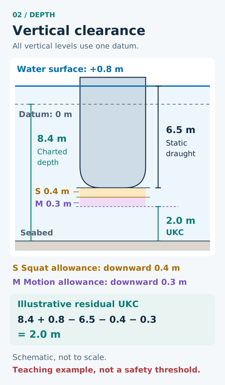
Use the same chart datum throughout an invented snapshot:
- Charted depth d: 8.4 m
- Water level η: +0.8 m
- Static draught T: 6.5 m
- Assumed downward squat contribution at the point considered: 0.4 m
- Assumed additional downward motion contribution at that same point and instant: 0.3 m
Water depth is 8.4 + 0.8 = 9.2 m. Static clearance is 9.2 − 6.5 = 2.7 m. The illustrated dynamic clearance is 2.7 − 0.4 − 0.3 = 2.0 m.
The result means only that these particular assumptions produce a 2.0 m separation in this simplified model. It does not establish adequate clearance, a probability of grounding, or compliance with any requirement. The two downward contributions are assumed simultaneous here solely to make the arithmetic unambiguous.
If the water-level assumption changes from +0.8 m to +0.5 m while everything else is held constant, the result becomes 1.7 m. This is a sensitivity comparison. It does not predict that the lower level will occur or suggest that all other effects would really remain unchanged.
Bathymetry describes evidence about the seabed
Bathymetry is information about underwater depth and shape. A chart is a selected representation of that information. A sounding is not a promise that every nearby point has the same depth. Survey coverage, feature-detection capability, horizontal positioning and depth uncertainty all affect what the data can support.
IHO S-44 Edition 6.2.0 treats these as distinct survey characteristics. Its uncertainty framework uses stated confidence levels and statistical assumptions. A survey meeting a specified order does not establish a universal operating clearance for every vessel.
The seabed can also change after measurement. Sediment movement, erosion, deposition or new obstructions can make an old survey less representative. “Accurately measured on that date” and “unchanged today” are different claims requiring different evidence.
A smooth colour map can hide this distinction. Interpolation produces values between observations, but it does not create newly observed seabed. A visually fine grid is not automatically a high-resolution survey, and extra decimal places do not reveal an undetected feature.
Horizontal uncertainty can become a depth problem
Imagine a seabed that rises by 0.1 m for every metre travelled horizontally across a slope. If a hypothetical position is displaced by 5 m in that direction, the corresponding seabed depth differs by 0.5 m. This is a geometric sensitivity example, not a distribution or bound for an actual position error.
The example explains why vertical accuracy alone is insufficient. Knowing the depth well at the wrong horizontal location can still misrepresent the clearance under a vessel. A broad vessel also occupies an area, while many simplified displays show a single point.
IHO S-66 Edition 2.0.0 explains depth-data quality and CATZOC categories, including unassessed data. It also notes that quality information does not itself describe subsequent seabed mobility. Quality categories need their definitions; they are not direct probabilities that a vessel will ground.
Combining uncertainty requires assumptions
A clearance estimate may contain uncertainty in surveyed depth, water level, draught, motion, position and model response. Some errors are random, some are systematic, and some inputs share a cause. Treating all uncertainties as independent can make the combined result look more certain than it is.
For an invented mathematical example only, suppose four independent, zero-mean errors have standard deviations of 0.20, 0.10, 0.10 and 0.15 m. A linear sum or difference of these terms has standard deviation √(0.20² + 0.10² + 0.10² + 0.15²), approximately 0.287 m. The signs do not remove independent variances.
This calculation is invalid if the numbers are incompatible quantities such as mixed confidence intervals and standard deviations, or if important correlations are omitted. A common datum bias is not averaged away. A systematic missing rock is not adequately represented merely by making a normal-distribution spread a little wider.
An uncertainty interval is also not a universal safety margin. Turning it into a probability of contact would need a suitable probabilistic model, relevant distributions and treatment of exposure over space and time. A confidence statement about a survey measurement is not automatically a grounding probability.
From contact possibility to grounding consequence
Grounding risk includes both the possibility of seabed contact and what contact could cause. Consequences depend on motion, hull structure, contact location, seabed material, flooding pathways, people and environmental exposure. Soft sediment and a concentrated hard obstruction do not create the same structural interaction.
The minimum modelled separation is therefore informative but incomplete. A result also needs the location and duration of low clearance, the assumptions that produced it and evidence quality. Neither an attractive colour scale nor a positive nominal number proves the absence of a hazard.
Questions to test understanding
Is chart depth minus draught always the actual clearance?
No. It omits water level relative to chart datum and any relevant dynamic or geometric effects. It may also combine values with inconsistent references.
Is squat just another word for heave?
No. Squat concerns speed-related sinkage and trim from hydrodynamic interaction. Heave describes vertical translation; it can arise in a different time-varying response.
Can the largest wave height be subtracted as hull motion?
Not without a response model. The water surface and each point on the hull need not move through the same distance or phase.
Does a 95% survey confidence statement imply a 5% grounding chance?
No. It concerns measurement uncertainty under stated assumptions, not the complete chain of vessel motion, exposure and contact.
What is the central lesson?
Clearance joins geometry, environment, motion and evidence quality. A subtraction becomes meaningful only after its references, timing, location and assumptions are clear. A useful educational calculation exposes those assumptions instead of turning its answer into a universal safe number.